You are here: Home > Network List > AV - Alaska Volcano Observatory Stations List
> Station AMKA Regional Station, Amchitka Island, Alaska > Earthquake Result Viewer
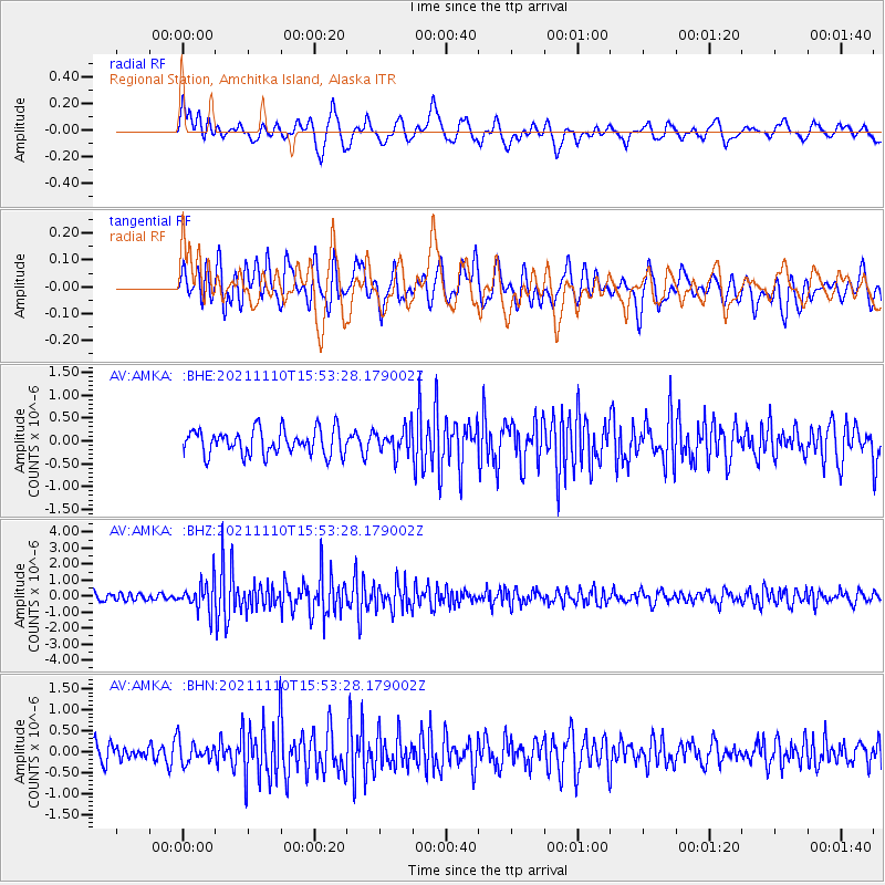
AMKA Regional Station, Amchitka Island, Alaska - Earthquake Result Viewer
*The percent match for this event was below the threshold and hence no stack was calculated.
| Earthquake location: |
Southeast Of Ryukyu Islands |
| Earthquake latitude/longitude: |
23.5/126.5 |
| Earthquake time(UTC): |
2021/11/10 (314) 15:45:13 GMT |
| Earthquake Depth: |
10 km |
| Earthquake Magnitude: |
6.6 Mww |
| Earthquake Catalog/Contributor: |
NEIC PDE/us |
|
| Network: |
AV Alaska Volcano Observatory |
| Station: |
AMKA Regional Station, Amchitka Island, Alaska |
| Lat/Lon: |
51.38 N/179.30 E |
| Elevation: |
116 m |
|
| Distance: |
48.9 deg |
| Az: |
41.485 deg |
| Baz: |
255.932 deg |
| Ray Param: |
$rayparam |
*The percent match for this event was below the threshold and hence was not used in the summary stack. |
|
| Radial Match: |
65.954834 % |
| Radial Bump: |
400 |
| Transverse Match: |
60.28698 % |
| Transverse Bump: |
400 |
| SOD ConfigId: |
26694651 |
| Insert Time: |
2021-11-24 15:51:42.775 +0000 |
| GWidth: |
2.5 |
| Max Bumps: |
400 |
| Tol: |
0.001 |
|
Signal To Noise
| Channel | StoN | STA | LTA |
| AV:AMKA: :BHZ:20211110T15:53:28.179002Z | 3.2854776 | 8.945879E-7 | 2.722855E-7 |
| AV:AMKA: :BHN:20211110T15:53:28.179002Z | 1.2274193 | 2.566878E-7 | 2.0912803E-7 |
| AV:AMKA: :BHE:20211110T15:53:28.179002Z | 1.0067788 | 2.791446E-7 | 2.7726506E-7 |
| Arrivals |
| Ps | |
| PpPs | |
| PsPs/PpSs | |


