You are here: Home > Network List > AV - Alaska Volcano Observatory Stations List
> Station KABU KABU - Katmai Volcanic Cluster, Alaska > Earthquake Result Viewer
KABU KABU - Katmai Volcanic Cluster, Alaska - Earthquake Result Viewer
| Earthquake location: |
Southeast Of Ryukyu Islands |
| Earthquake latitude/longitude: |
23.5/126.5 |
| Earthquake time(UTC): |
2021/11/10 (314) 15:45:13 GMT |
| Earthquake Depth: |
10 km |
| Earthquake Magnitude: |
6.6 Mww |
| Earthquake Catalog/Contributor: |
NEIC PDE/us |
|
| Network: |
AV Alaska Volcano Observatory |
| Station: |
KABU KABU - Katmai Volcanic Cluster, Alaska |
| Lat/Lon: |
58.27 N/155.28 W |
| Elevation: |
1065 m |
|
| Distance: |
64.1 deg |
| Az: |
35.092 deg |
| Baz: |
273.253 deg |
| Ray Param: |
0.059111707 |
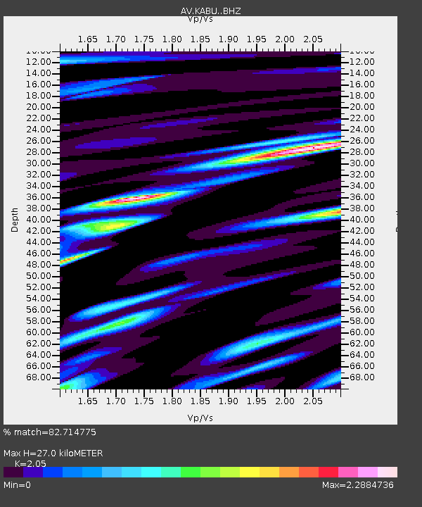
| Estimated Moho Depth: |
27.0 km |
| Estimated Crust Vp/Vs: |
2.05 |
| Assumed Crust Vp: |
6.438 km/s |
| Estimated Crust Vs: |
3.141 km/s |
| Estimated Crust Poisson's Ratio: |
0.34 |
|
| Radial Match: |
82.714775 % |
| Radial Bump: |
400 |
| Transverse Match: |
77.21892 % |
| Transverse Bump: |
400 |
| SOD ConfigId: |
26694651 |
| Insert Time: |
2021-11-24 15:52:17.411 +0000 |
| GWidth: |
2.5 |
| Max Bumps: |
400 |
| Tol: |
0.001 |
|
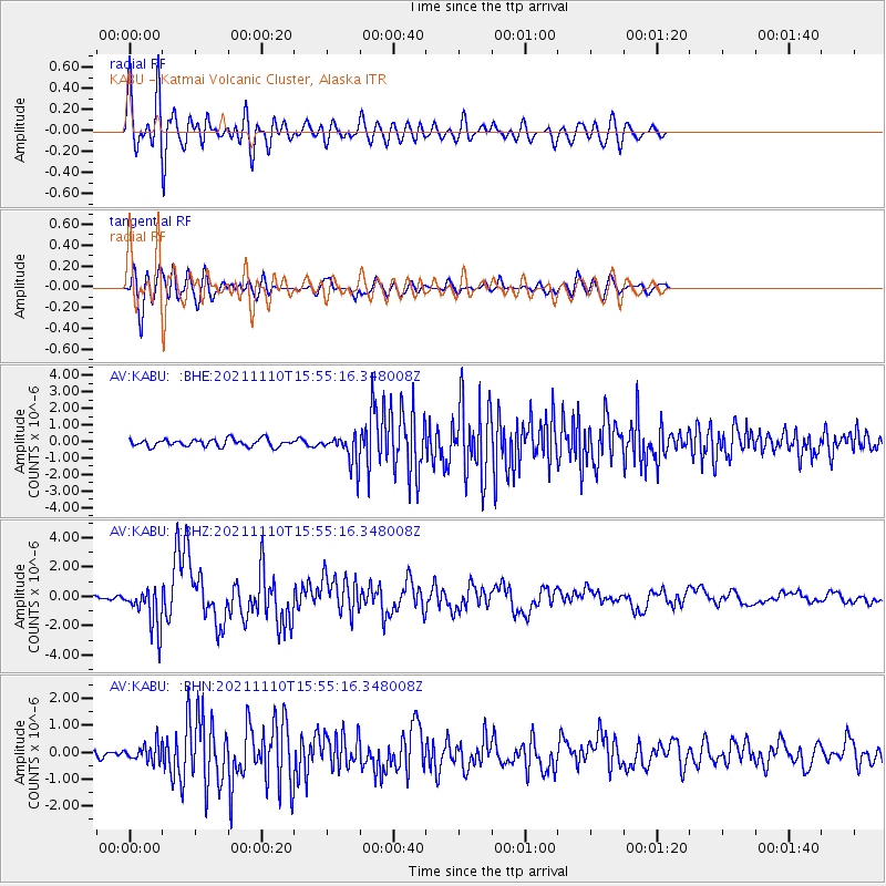
Signal To Noise
| Channel | StoN | STA | LTA |
| AV:KABU: :BHZ:20211110T15:55:16.348008Z | 8.75569 | 1.4278742E-6 | 1.6307956E-7 |
| AV:KABU: :BHN:20211110T15:55:16.348008Z | 1.6125569 | 3.1474698E-7 | 1.9518502E-7 |
| AV:KABU: :BHE:20211110T15:55:16.348008Z | 4.004601 | 8.9904995E-7 | 2.2450425E-7 |
| Arrivals |
| Ps | 4.6 SECOND |
| PpPs | 12 SECOND |
| PsPs/PpSs | 17 SECOND |


