You are here: Home > Network List > AV - Alaska Volcano Observatory Stations List
> Station KAHG Katmai Hook Glacier, Alaska > Earthquake Result Viewer
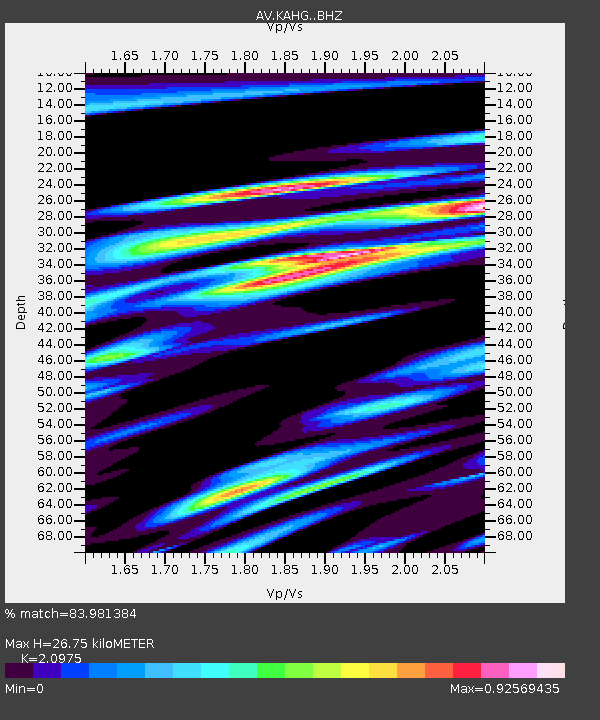
KAHG Katmai Hook Glacier, Alaska - Earthquake Result Viewer
| Earthquake location: |
Southeast Of Ryukyu Islands |
| Earthquake latitude/longitude: |
23.5/126.5 |
| Earthquake time(UTC): |
2021/11/10 (314) 15:45:13 GMT |
| Earthquake Depth: |
10 km |
| Earthquake Magnitude: |
6.6 Mww |
| Earthquake Catalog/Contributor: |
NEIC PDE/us |
|
| Network: |
AV Alaska Volcano Observatory |
| Station: |
KAHG Katmai Hook Glacier, Alaska |
| Lat/Lon: |
58.49 N/154.55 W |
| Elevation: |
923 m |
|
| Distance: |
64.5 deg |
| Az: |
34.819 deg |
| Baz: |
273.758 deg |
| Ray Param: |
0.05887269 |
| Estimated Moho Depth: |
26.75 km |
| Estimated Crust Vp/Vs: |
2.10 |
| Assumed Crust Vp: |
6.438 km/s |
| Estimated Crust Vs: |
3.069 km/s |
| Estimated Crust Poisson's Ratio: |
0.35 |
|
| Radial Match: |
83.981384 % |
| Radial Bump: |
400 |
| Transverse Match: |
73.257614 % |
| Transverse Bump: |
400 |
| SOD ConfigId: |
26694651 |
| Insert Time: |
2021-11-24 15:52:19.696 +0000 |
| GWidth: |
2.5 |
| Max Bumps: |
400 |
| Tol: |
0.001 |
|

Signal To Noise
| Channel | StoN | STA | LTA |
| AV:KAHG: :BHZ:20211110T15:55:18.780015Z | 5.017788 | 1.2208682E-6 | 2.4330805E-7 |
| AV:KAHG: :BHN:20211110T15:55:18.780015Z | 1.4622658 | 3.150892E-7 | 2.1548011E-7 |
| AV:KAHG: :BHE:20211110T15:55:18.780015Z | 2.7340841 | 5.763647E-7 | 2.1080722E-7 |
| Arrivals |
| Ps | 4.7 SECOND |
| PpPs | 12 SECOND |
| PsPs/PpSs | 17 SECOND |


