You are here: Home > Network List > AV - Alaska Volcano Observatory Stations List
> Station N25K Chitina, Valdez-Cordova, AK, USA > Earthquake Result Viewer
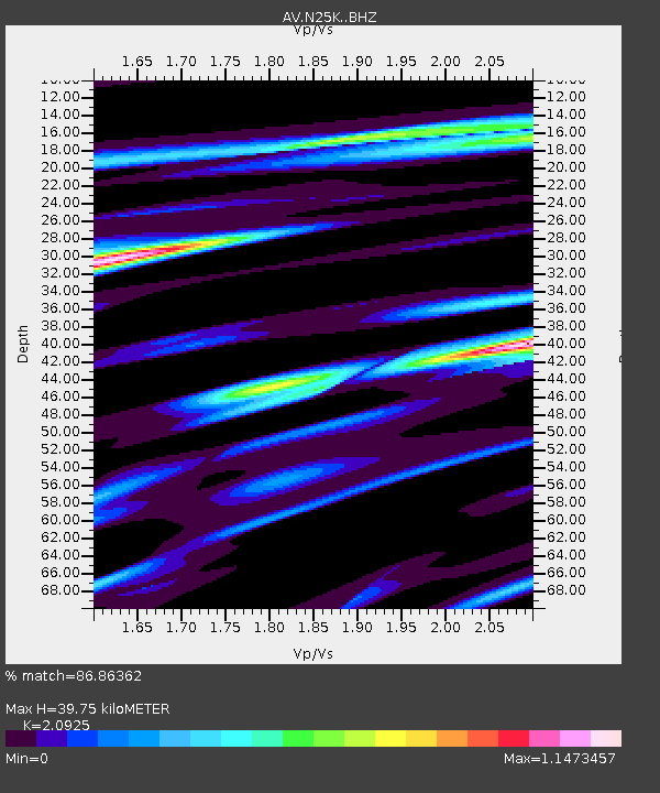
N25K Chitina, Valdez-Cordova, AK, USA - Earthquake Result Viewer
| Earthquake location: |
Southeast Of Ryukyu Islands |
| Earthquake latitude/longitude: |
23.5/126.5 |
| Earthquake time(UTC): |
2021/11/10 (314) 15:45:13 GMT |
| Earthquake Depth: |
10 km |
| Earthquake Magnitude: |
6.6 Mww |
| Earthquake Catalog/Contributor: |
NEIC PDE/us |
|
| Network: |
AV Alaska Volcano Observatory |
| Station: |
N25K Chitina, Valdez-Cordova, AK, USA |
| Lat/Lon: |
61.61 N/144.60 W |
| Elevation: |
1087 m |
|
| Distance: |
69.1 deg |
| Az: |
30.774 deg |
| Baz: |
280.778 deg |
| Ray Param: |
0.055888247 |
| Estimated Moho Depth: |
39.75 km |
| Estimated Crust Vp/Vs: |
2.09 |
| Assumed Crust Vp: |
6.566 km/s |
| Estimated Crust Vs: |
3.138 km/s |
| Estimated Crust Poisson's Ratio: |
0.35 |
|
| Radial Match: |
86.86362 % |
| Radial Bump: |
400 |
| Transverse Match: |
80.809555 % |
| Transverse Bump: |
400 |
| SOD ConfigId: |
26694651 |
| Insert Time: |
2021-11-24 15:52:43.888 +0000 |
| GWidth: |
2.5 |
| Max Bumps: |
400 |
| Tol: |
0.001 |
|

Signal To Noise
| Channel | StoN | STA | LTA |
| AV:N25K: :BHZ:20211110T15:55:47.749986Z | 4.031164 | 6.191787E-7 | 1.5359798E-7 |
| AV:N25K: :BHN:20211110T15:55:47.749986Z | 1.183163 | 1.9176403E-7 | 1.6207744E-7 |
| AV:N25K: :BHE:20211110T15:55:47.749986Z | 1.9594487 | 3.3628373E-7 | 1.7162161E-7 |
| Arrivals |
| Ps | 6.8 SECOND |
| PpPs | 18 SECOND |
| PsPs/PpSs | 25 SECOND |


