You are here: Home > Network List > AV - Alaska Volcano Observatory Stations List
> Station P18K Big Mountain, AK, USA > Earthquake Result Viewer
P18K Big Mountain, AK, USA - Earthquake Result Viewer
| Earthquake location: |
Southeast Of Ryukyu Islands |
| Earthquake latitude/longitude: |
23.5/126.5 |
| Earthquake time(UTC): |
2021/11/10 (314) 15:45:13 GMT |
| Earthquake Depth: |
10 km |
| Earthquake Magnitude: |
6.6 Mww |
| Earthquake Catalog/Contributor: |
NEIC PDE/us |
|
| Network: |
AV Alaska Volcano Observatory |
| Station: |
P18K Big Mountain, AK, USA |
| Lat/Lon: |
59.39 N/155.23 W |
| Elevation: |
680 m |
|
| Distance: |
64.1 deg |
| Az: |
33.842 deg |
| Baz: |
272.753 deg |
| Ray Param: |
0.05913301 |
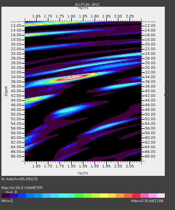
| Estimated Moho Depth: |
34.0 km |
| Estimated Crust Vp/Vs: |
1.80 |
| Assumed Crust Vp: |
6.438 km/s |
| Estimated Crust Vs: |
3.577 km/s |
| Estimated Crust Poisson's Ratio: |
0.28 |
|
| Radial Match: |
95.85025 % |
| Radial Bump: |
400 |
| Transverse Match: |
86.08025 % |
| Transverse Bump: |
400 |
| SOD ConfigId: |
26694651 |
| Insert Time: |
2021-11-24 15:52:49.462 +0000 |
| GWidth: |
2.5 |
| Max Bumps: |
400 |
| Tol: |
0.001 |
|

Signal To Noise
| Channel | StoN | STA | LTA |
| AV:P18K: :BHZ:20211110T15:55:16.15001Z | 7.1561823 | 1.3507032E-6 | 1.8874634E-7 |
| AV:P18K: :BHN:20211110T15:55:16.15001Z | 0.9529527 | 1.9184002E-7 | 2.0131115E-7 |
| AV:P18K: :BHE:20211110T15:55:16.15001Z | 2.8021157 | 4.9671536E-7 | 1.772644E-7 |
| Arrivals |
| Ps | 4.4 SECOND |
| PpPs | 14 SECOND |
| PsPs/PpSs | 19 SECOND |


