You are here: Home > Network List > AV - Alaska Volcano Observatory Stations List
> Station PLK3 Mt. Peulik Volcano 3, Alaska > Earthquake Result Viewer
PLK3 Mt. Peulik Volcano 3, Alaska - Earthquake Result Viewer
| Earthquake location: |
Southeast Of Ryukyu Islands |
| Earthquake latitude/longitude: |
23.5/126.5 |
| Earthquake time(UTC): |
2021/11/10 (314) 15:45:13 GMT |
| Earthquake Depth: |
10 km |
| Earthquake Magnitude: |
6.6 Mww |
| Earthquake Catalog/Contributor: |
NEIC PDE/us |
|
| Network: |
AV Alaska Volcano Observatory |
| Station: |
PLK3 Mt. Peulik Volcano 3, Alaska |
| Lat/Lon: |
57.69 N/156.27 W |
| Elevation: |
494 m |
|
| Distance: |
63.7 deg |
| Az: |
35.773 deg |
| Baz: |
272.717 deg |
| Ray Param: |
0.05943839 |
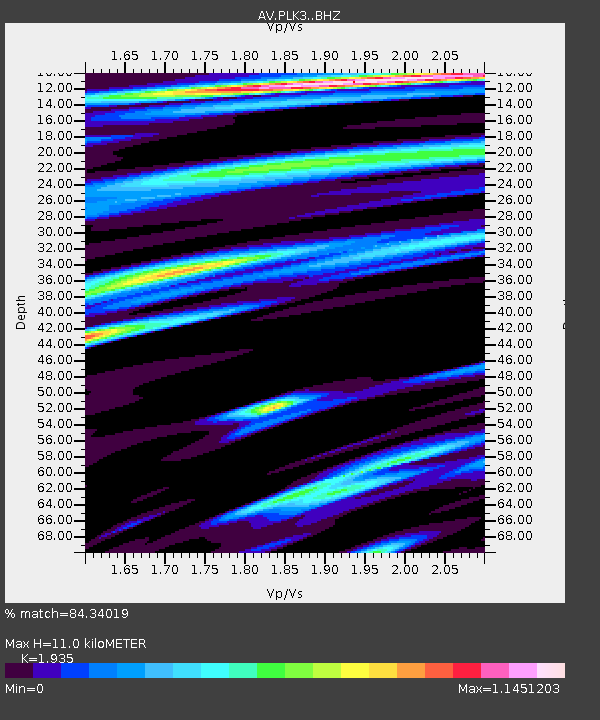
| Estimated Moho Depth: |
11.0 km |
| Estimated Crust Vp/Vs: |
1.93 |
| Assumed Crust Vp: |
6.1 km/s |
| Estimated Crust Vs: |
3.152 km/s |
| Estimated Crust Poisson's Ratio: |
0.32 |
|
| Radial Match: |
84.34019 % |
| Radial Bump: |
400 |
| Transverse Match: |
81.52876 % |
| Transverse Bump: |
400 |
| SOD ConfigId: |
26694651 |
| Insert Time: |
2021-11-24 15:52:55.686 +0000 |
| GWidth: |
2.5 |
| Max Bumps: |
400 |
| Tol: |
0.001 |
|

Signal To Noise
| Channel | StoN | STA | LTA |
| AV:PLK3: :BHZ:20211110T15:55:13.100022Z | 2.9689941 | 9.740957E-7 | 3.2808944E-7 |
| AV:PLK3: :BHN:20211110T15:55:13.100022Z | 1.0125531 | 1.9681087E-7 | 1.9437091E-7 |
| AV:PLK3: :BHE:20211110T15:55:13.100022Z | 2.0541072 | 5.147011E-7 | 2.5057167E-7 |
| Arrivals |
| Ps | 1.7 SECOND |
| PpPs | 5.1 SECOND |
| PsPs/PpSs | 6.9 SECOND |


