You are here: Home > Network List > AV - Alaska Volcano Observatory Stations List
> Station SPCL Chakachamna Lake, Mount Spurr, Alaska > Earthquake Result Viewer
SPCL Chakachamna Lake, Mount Spurr, Alaska - Earthquake Result Viewer
| Earthquake location: |
Southeast Of Ryukyu Islands |
| Earthquake latitude/longitude: |
23.5/126.5 |
| Earthquake time(UTC): |
2021/11/10 (314) 15:45:13 GMT |
| Earthquake Depth: |
10 km |
| Earthquake Magnitude: |
6.6 Mww |
| Earthquake Catalog/Contributor: |
NEIC PDE/us |
|
| Network: |
AV Alaska Volcano Observatory |
| Station: |
SPCL Chakachamna Lake, Mount Spurr, Alaska |
| Lat/Lon: |
61.20 N/152.34 W |
| Elevation: |
1274 m |
|
| Distance: |
65.4 deg |
| Az: |
31.748 deg |
| Baz: |
274.366 deg |
| Ray Param: |
0.058269553 |
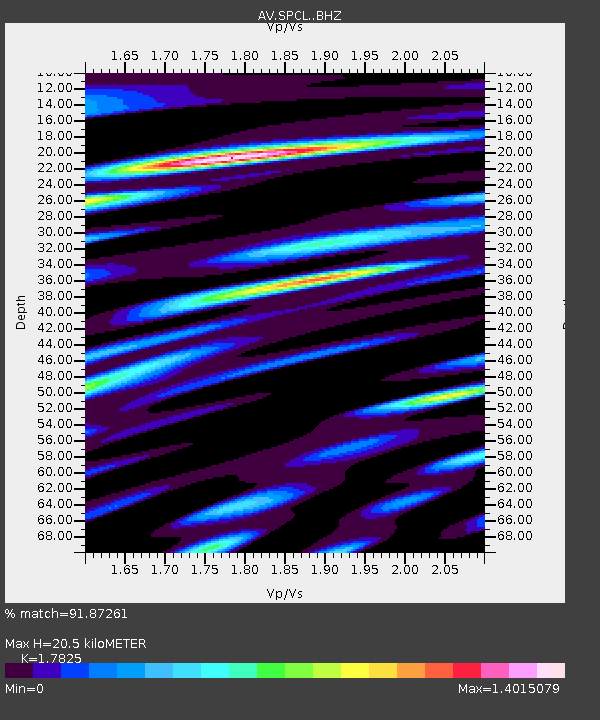
| Estimated Moho Depth: |
20.5 km |
| Estimated Crust Vp/Vs: |
1.78 |
| Assumed Crust Vp: |
6.566 km/s |
| Estimated Crust Vs: |
3.684 km/s |
| Estimated Crust Poisson's Ratio: |
0.27 |
|
| Radial Match: |
91.87261 % |
| Radial Bump: |
400 |
| Transverse Match: |
89.23357 % |
| Transverse Bump: |
400 |
| SOD ConfigId: |
26694651 |
| Insert Time: |
2021-11-24 15:53:19.320 +0000 |
| GWidth: |
2.5 |
| Max Bumps: |
400 |
| Tol: |
0.001 |
|

Signal To Noise
| Channel | StoN | STA | LTA |
| AV:SPCL: :BHZ:20211110T15:55:24.759996Z | 6.012147 | 6.489838E-7 | 1.0794544E-7 |
| AV:SPCL: :BHN:20211110T15:55:24.759996Z | 0.8826316 | 7.476269E-8 | 8.47043E-8 |
| AV:SPCL: :BHE:20211110T15:55:24.759996Z | 2.167026 | 2.9451064E-7 | 1.3590545E-7 |
| Arrivals |
| Ps | 2.6 SECOND |
| PpPs | 8.3 SECOND |
| PsPs/PpSs | 11 SECOND |


