You are here: Home > Network List > AV - Alaska Volcano Observatory Stations List
> Station KEL Katmai Kelez, Alaska > Earthquake Result Viewer
KEL Katmai Kelez, Alaska - Earthquake Result Viewer
| Earthquake location: |
Southeast Of Ryukyu Islands |
| Earthquake latitude/longitude: |
23.5/126.5 |
| Earthquake time(UTC): |
2021/11/10 (314) 15:45:13 GMT |
| Earthquake Depth: |
10 km |
| Earthquake Magnitude: |
6.6 Mww |
| Earthquake Catalog/Contributor: |
NEIC PDE/us |
|
| Network: |
AV Alaska Volcano Observatory |
| Station: |
KEL Katmai Kelez, Alaska |
| Lat/Lon: |
58.44 N/155.74 W |
| Elevation: |
975 m |
|
| Distance: |
63.9 deg |
| Az: |
34.919 deg |
| Baz: |
272.785 deg |
| Ray Param: |
0.05928086 |
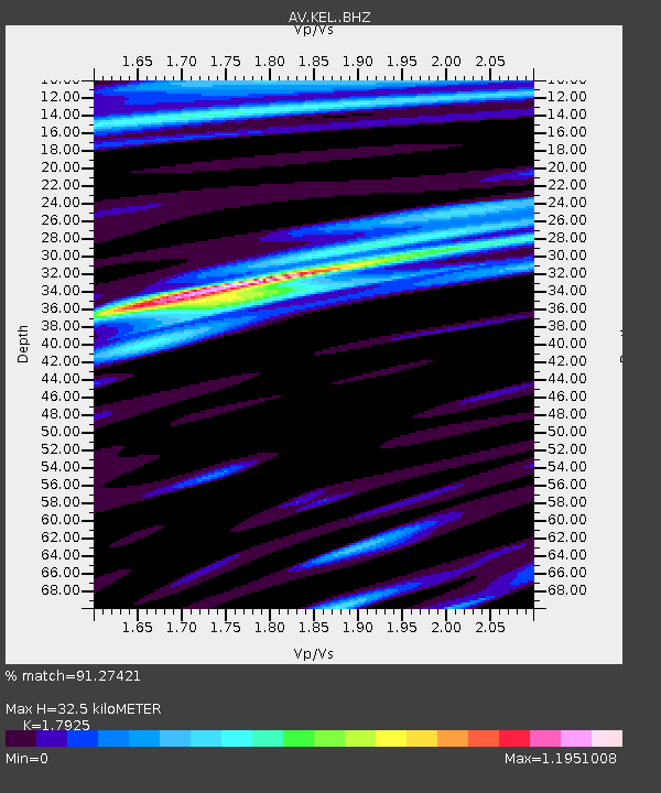
| Estimated Moho Depth: |
32.5 km |
| Estimated Crust Vp/Vs: |
1.79 |
| Assumed Crust Vp: |
6.438 km/s |
| Estimated Crust Vs: |
3.592 km/s |
| Estimated Crust Poisson's Ratio: |
0.27 |
|
| Radial Match: |
91.27421 % |
| Radial Bump: |
400 |
| Transverse Match: |
78.68375 % |
| Transverse Bump: |
400 |
| SOD ConfigId: |
26694651 |
| Insert Time: |
2021-11-24 15:53:44.479 +0000 |
| GWidth: |
2.5 |
| Max Bumps: |
400 |
| Tol: |
0.001 |
|

Signal To Noise
| Channel | StoN | STA | LTA |
| AV:KEL: :BHZ:20211110T15:55:14.699021Z | 6.58363 | 9.29811E-7 | 1.4123074E-7 |
| AV:KEL: :BHN:20211110T15:55:14.699021Z | 2.1769826 | 2.464475E-7 | 1.13206E-7 |
| AV:KEL: :BHE:20211110T15:55:14.699021Z | 2.9293942 | 4.8861904E-7 | 1.6679866E-7 |
| Arrivals |
| Ps | 4.2 SECOND |
| PpPs | 14 SECOND |
| PsPs/PpSs | 18 SECOND |


