You are here: Home > Network List > LI - Laser Interferometer Gravitational-Wave Experiment (LIGO) Stations List
> Station LTH LTH, Bishop, CA, USA > Earthquake Result Viewer
LTH LTH, Bishop, CA, USA - Earthquake Result Viewer
| Earthquake location: |
Tonga Islands |
| Earthquake latitude/longitude: |
-15.2/-173.6 |
| Earthquake time(UTC): |
2006/07/07 (188) 07:26:12 GMT |
| Earthquake Depth: |
35 km |
| Earthquake Magnitude: |
5.7 MB, 5.9 MS, 6.0 MW, 6.0 MW |
| Earthquake Catalog/Contributor: |
WHDF/NEIC |
|
| Network: |
LI Laser Interferometer Gravitational-Wave Experiment (LIGO) |
| Station: |
LTH LTH, Bishop, CA, USA |
| Lat/Lon: |
46.46 N/119.42 W |
| Elevation: |
157 m |
|
| Distance: |
78.4 deg |
| Az: |
34.915 deg |
| Baz: |
233.055 deg |
| Ray Param: |
0.049637236 |
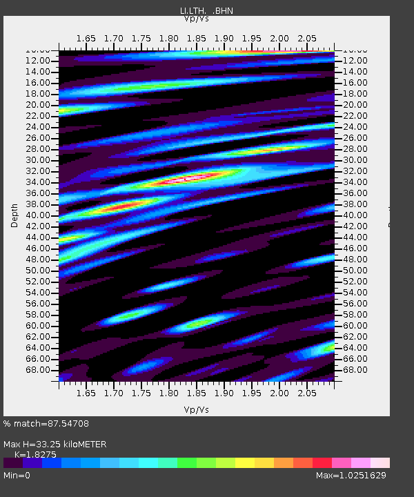
| Estimated Moho Depth: |
33.25 km |
| Estimated Crust Vp/Vs: |
1.83 |
| Assumed Crust Vp: |
6.419 km/s |
| Estimated Crust Vs: |
3.513 km/s |
| Estimated Crust Poisson's Ratio: |
0.29 |
|
| Radial Match: |
87.54708 % |
| Radial Bump: |
400 |
| Transverse Match: |
83.84785 % |
| Transverse Bump: |
400 |
| SOD ConfigId: |
5423 |
| Insert Time: |
2010-03-09 14:04:34.085 +0000 |
| GWidth: |
2.5 |
| Max Bumps: |
400 |
| Tol: |
0.001 |
|

Signal To Noise
| Channel | StoN | STA | LTA |
| LI:LTH: :BHN:20060707T07:37:38.350007Z | 4.242789 | 2.6123618E-7 | 6.1571804E-8 |
| LI:LTH: :BHE:20060707T07:37:38.350007Z | 3.644729 | 1.7724633E-7 | 4.863087E-8 |
| LI:LTH: :BHZ:20060707T07:37:38.350007Z | 7.087521 | 5.9590997E-7 | 8.4078756E-8 |
| Arrivals |
| Ps | 4.4 SECOND |
| PpPs | 14 SECOND |
| PsPs/PpSs | 19 SECOND |


