You are here: Home > Network List > CI - Caltech Regional Seismic Network Stations List
> Station MPM Manuel Prospect Mine, California, USA > Earthquake Result Viewer
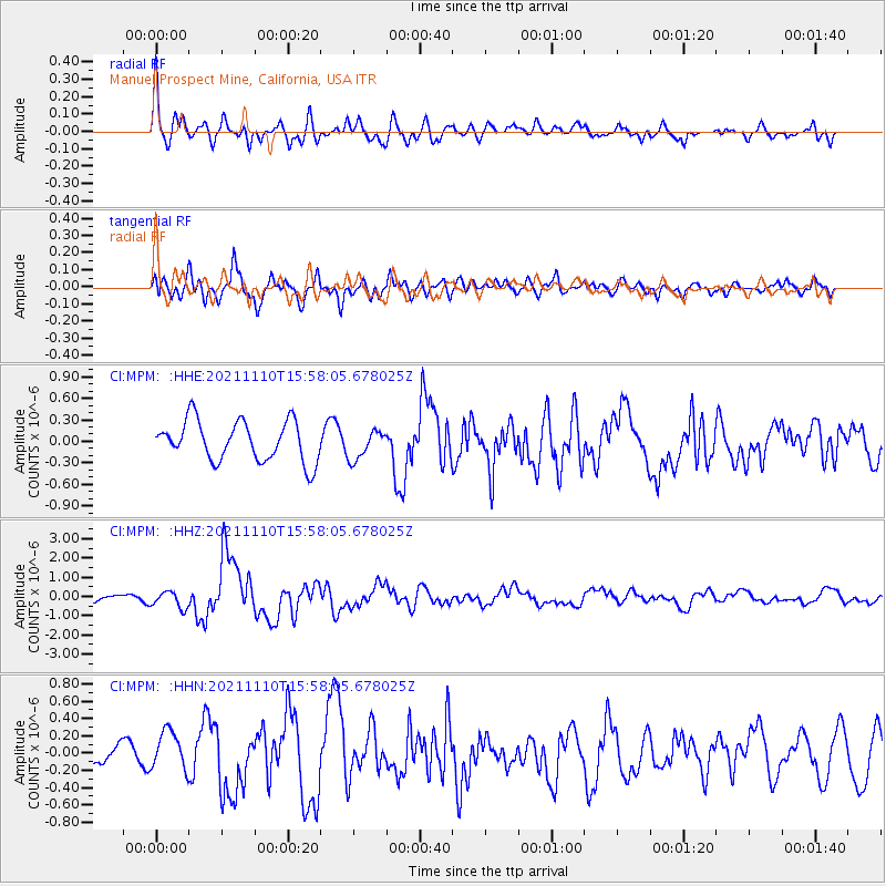
MPM Manuel Prospect Mine, California, USA - Earthquake Result Viewer
*The percent match for this event was below the threshold and hence no stack was calculated.
| Earthquake location: |
Southeast Of Ryukyu Islands |
| Earthquake latitude/longitude: |
23.5/126.5 |
| Earthquake time(UTC): |
2021/11/10 (314) 15:45:13 GMT |
| Earthquake Depth: |
10 km |
| Earthquake Magnitude: |
6.6 Mww |
| Earthquake Catalog/Contributor: |
NEIC PDE/us |
|
| Network: |
CI Caltech Regional Seismic Network |
| Station: |
MPM Manuel Prospect Mine, California, USA |
| Lat/Lon: |
36.06 N/117.49 W |
| Elevation: |
185 m |
|
| Distance: |
95.4 deg |
| Az: |
46.996 deg |
| Baz: |
304.077 deg |
| Ray Param: |
$rayparam |
*The percent match for this event was below the threshold and hence was not used in the summary stack. |
|
| Radial Match: |
53.45315 % |
| Radial Bump: |
400 |
| Transverse Match: |
78.38084 % |
| Transverse Bump: |
400 |
| SOD ConfigId: |
26694651 |
| Insert Time: |
2021-11-24 15:55:51.313 +0000 |
| GWidth: |
2.5 |
| Max Bumps: |
400 |
| Tol: |
0.001 |
|
Signal To Noise
| Channel | StoN | STA | LTA |
| CI:MPM: :HHZ:20211110T15:58:05.678025Z | 2.5332022 | 4.3168646E-7 | 1.7041137E-7 |
| CI:MPM: :HHN:20211110T15:58:05.678025Z | 2.1638508 | 2.3722231E-7 | 1.096297E-7 |
| CI:MPM: :HHE:20211110T15:58:05.678025Z | 0.7224534 | 2.0252114E-7 | 2.8032414E-7 |
| Arrivals |
| Ps | |
| PpPs | |
| PsPs/PpSs | |


