You are here: Home > Network List > G - GEOSCOPE Stations List
> Station FOMA Nahampoana reservation, Fort Dauphin, Madagascar > Earthquake Result Viewer
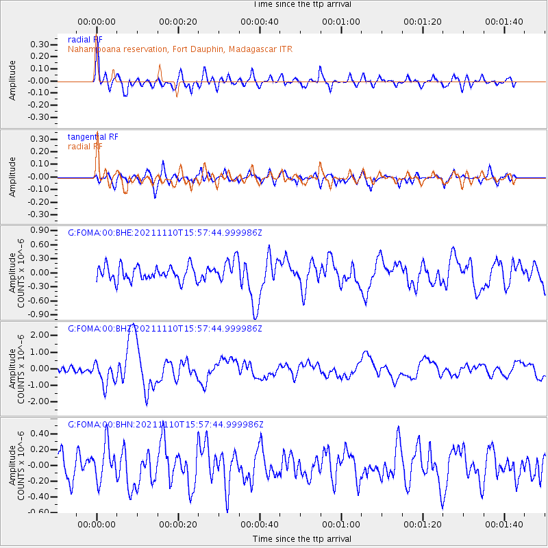
FOMA Nahampoana reservation, Fort Dauphin, Madagascar - Earthquake Result Viewer
*The percent match for this event was below the threshold and hence no stack was calculated.
| Earthquake location: |
Southeast Of Ryukyu Islands |
| Earthquake latitude/longitude: |
23.5/126.5 |
| Earthquake time(UTC): |
2021/11/10 (314) 15:45:13 GMT |
| Earthquake Depth: |
10 km |
| Earthquake Magnitude: |
6.6 Mww |
| Earthquake Catalog/Contributor: |
NEIC PDE/us |
|
| Network: |
G GEOSCOPE |
| Station: |
FOMA Nahampoana reservation, Fort Dauphin, Madagascar |
| Lat/Lon: |
24.98 S/46.98 E |
| Elevation: |
26 m |
|
| Distance: |
90.9 deg |
| Az: |
243.186 deg |
| Baz: |
64.487 deg |
| Ray Param: |
$rayparam |
*The percent match for this event was below the threshold and hence was not used in the summary stack. |
|
| Radial Match: |
76.953415 % |
| Radial Bump: |
400 |
| Transverse Match: |
70.00383 % |
| Transverse Bump: |
400 |
| SOD ConfigId: |
26694651 |
| Insert Time: |
2021-11-24 15:57:55.717 +0000 |
| GWidth: |
2.5 |
| Max Bumps: |
400 |
| Tol: |
0.001 |
|
Signal To Noise
| Channel | StoN | STA | LTA |
| G:FOMA:00:BHZ:20211110T15:57:44.999986Z | 3.2515314 | 7.2218063E-7 | 2.2210476E-7 |
| G:FOMA:00:BHN:20211110T15:57:44.999986Z | 1.6413248 | 2.3983927E-7 | 1.4612542E-7 |
| G:FOMA:00:BHE:20211110T15:57:44.999986Z | 1.628865 | 2.4910557E-7 | 1.5293199E-7 |
| Arrivals |
| Ps | |
| PpPs | |
| PsPs/PpSs | |


