You are here: Home > Network List > IW - Intermountain West Stations List
> Station MOOW Moose Ponds, Wyoming, USA > Earthquake Result Viewer
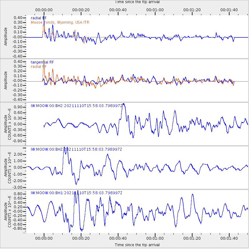
MOOW Moose Ponds, Wyoming, USA - Earthquake Result Viewer
*The percent match for this event was below the threshold and hence no stack was calculated.
| Earthquake location: |
Southeast Of Ryukyu Islands |
| Earthquake latitude/longitude: |
23.5/126.5 |
| Earthquake time(UTC): |
2021/11/10 (314) 15:45:13 GMT |
| Earthquake Depth: |
10 km |
| Earthquake Magnitude: |
6.6 Mww |
| Earthquake Catalog/Contributor: |
NEIC PDE/us |
|
| Network: |
IW Intermountain West |
| Station: |
MOOW Moose Ponds, Wyoming, USA |
| Lat/Lon: |
43.75 N/110.74 W |
| Elevation: |
2128 m |
|
| Distance: |
95.0 deg |
| Az: |
37.706 deg |
| Baz: |
309.237 deg |
| Ray Param: |
$rayparam |
*The percent match for this event was below the threshold and hence was not used in the summary stack. |
|
| Radial Match: |
65.492294 % |
| Radial Bump: |
400 |
| Transverse Match: |
71.48328 % |
| Transverse Bump: |
400 |
| SOD ConfigId: |
26694651 |
| Insert Time: |
2021-11-24 16:00:21.208 +0000 |
| GWidth: |
2.5 |
| Max Bumps: |
400 |
| Tol: |
0.001 |
|
Signal To Noise
| Channel | StoN | STA | LTA |
| IW:MOOW:00:BHZ:20211110T15:58:03.798997Z | 1.1111197 | 4.031838E-7 | 3.628626E-7 |
| IW:MOOW:00:BH1:20211110T15:58:03.798997Z | 1.5091914 | 3.6361067E-7 | 2.4093077E-7 |
| IW:MOOW:00:BH2:20211110T15:58:03.798997Z | 2.7937262 | 2.9940523E-7 | 1.0717057E-7 |
| Arrivals |
| Ps | |
| PpPs | |
| PsPs/PpSs | |


