You are here: Home > Network List > KO - Kandilli Observatory Digital Broadband Seismic Network Stations List
> Station GURO KO.GURO > Earthquake Result Viewer
GURO KO.GURO - Earthquake Result Viewer
| Earthquake location: |
Southeast Of Ryukyu Islands |
| Earthquake latitude/longitude: |
23.5/126.5 |
| Earthquake time(UTC): |
2021/11/10 (314) 15:45:13 GMT |
| Earthquake Depth: |
10 km |
| Earthquake Magnitude: |
6.6 Mww |
| Earthquake Catalog/Contributor: |
NEIC PDE/us |
|
| Network: |
KO Kandilli Observatory Digital Broadband Seismic Network |
| Station: |
GURO KO.GURO |
| Lat/Lon: |
38.55 N/42.03 E |
| Elevation: |
1388 m |
|
| Distance: |
71.6 deg |
| Az: |
304.655 deg |
| Baz: |
74.327 deg |
| Ray Param: |
0.054250013 |
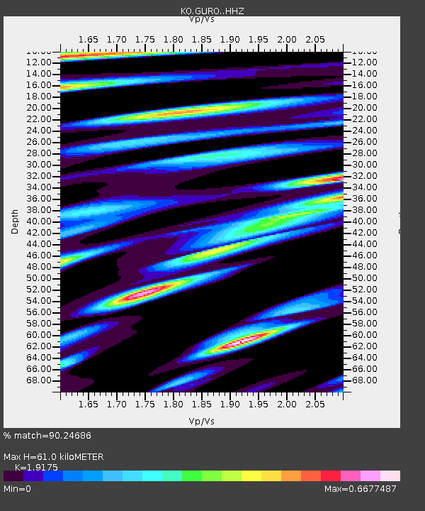
| Estimated Moho Depth: |
61.0 km |
| Estimated Crust Vp/Vs: |
1.92 |
| Assumed Crust Vp: |
6.35 km/s |
| Estimated Crust Vs: |
3.312 km/s |
| Estimated Crust Poisson's Ratio: |
0.31 |
|
| Radial Match: |
90.24686 % |
| Radial Bump: |
400 |
| Transverse Match: |
93.20329 % |
| Transverse Bump: |
400 |
| SOD ConfigId: |
26694651 |
| Insert Time: |
2021-11-24 16:00:36.614 +0000 |
| GWidth: |
2.5 |
| Max Bumps: |
400 |
| Tol: |
0.001 |
|

Signal To Noise
| Channel | StoN | STA | LTA |
| KO:GURO: :HHZ:20211110T15:56:02.970018Z | 9.412463 | 6.6818177E-7 | 7.0989046E-8 |
| KO:GURO: :HHN:20211110T15:56:02.970018Z | 2.2234619 | 2.456467E-7 | 1.1047939E-7 |
| KO:GURO: :HHE:20211110T15:56:02.970018Z | 3.7587328 | 2.2069965E-7 | 5.8716502E-8 |
| Arrivals |
| Ps | 9.1 SECOND |
| PpPs | 27 SECOND |
| PsPs/PpSs | 36 SECOND |


