You are here: Home > Network List > LI - Laser Interferometer Gravitational-Wave Experiment (LIGO) Stations List
> Station LTH LTH, Bishop, CA, USA > Earthquake Result Viewer
LTH LTH, Bishop, CA, USA - Earthquake Result Viewer
| Earthquake location: |
Near S. Coast Of Western Honshu |
| Earthquake latitude/longitude: |
33.1/136.6 |
| Earthquake time(UTC): |
2004/09/05 (249) 10:07:07 GMT |
| Earthquake Depth: |
14 km |
| Earthquake Magnitude: |
6.7 MB, 7.0 MS, 7.2 MW, 7.0 MW |
| Earthquake Catalog/Contributor: |
WHDF/NEIC |
|
| Network: |
LI Laser Interferometer Gravitational-Wave Experiment (LIGO) |
| Station: |
LTH LTH, Bishop, CA, USA |
| Lat/Lon: |
46.46 N/119.42 W |
| Elevation: |
157 m |
|
| Distance: |
75.4 deg |
| Az: |
43.89 deg |
| Baz: |
302.636 deg |
| Ray Param: |
0.051699065 |
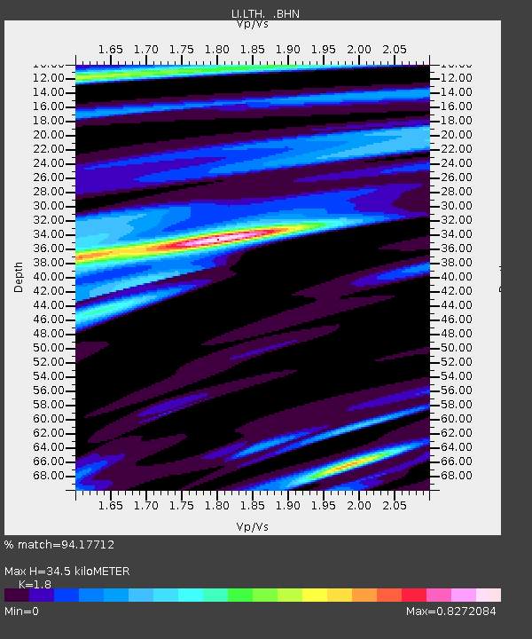
| Estimated Moho Depth: |
34.5 km |
| Estimated Crust Vp/Vs: |
1.80 |
| Assumed Crust Vp: |
6.419 km/s |
| Estimated Crust Vs: |
3.566 km/s |
| Estimated Crust Poisson's Ratio: |
0.28 |
|
| Radial Match: |
94.17712 % |
| Radial Bump: |
400 |
| Transverse Match: |
87.723175 % |
| Transverse Bump: |
400 |
| SOD ConfigId: |
2459 |
| Insert Time: |
2010-03-09 14:05:05.219 +0000 |
| GWidth: |
2.5 |
| Max Bumps: |
400 |
| Tol: |
0.001 |
|

Signal To Noise
| Channel | StoN | STA | LTA |
| LI:LTH: :BHN:20040905T10:18:19.528008Z | 12.715159 | 1.5459276E-6 | 1.2158146E-7 |
| LI:LTH: :BHE:20040905T10:18:19.528008Z | 33.886597 | 4.543116E-6 | 1.3406823E-7 |
| LI:LTH: :BHZ:20040905T10:18:19.528008Z | 103.63556 | 1.2492507E-5 | 1.2054267E-7 |
| Arrivals |
| Ps | 4.4 SECOND |
| PpPs | 15 SECOND |
| PsPs/PpSs | 19 SECOND |


