You are here: Home > Network List > LI - Laser Interferometer Gravitational-Wave Experiment (LIGO) Stations List
> Station LTH LTH, Bishop, CA, USA > Earthquake Result Viewer
LTH LTH, Bishop, CA, USA - Earthquake Result Viewer
| Earthquake location: |
Dodecanese Islands, Greece |
| Earthquake latitude/longitude: |
35.8/27.9 |
| Earthquake time(UTC): |
2008/07/15 (197) 03:26:34 GMT |
| Earthquake Depth: |
52 km |
| Earthquake Magnitude: |
6.5 MB, 6.4 MW, 6.4 MW |
| Earthquake Catalog/Contributor: |
WHDF/NEIC |
|
| Network: |
LI Laser Interferometer Gravitational-Wave Experiment (LIGO) |
| Station: |
LTH LTH, Bishop, CA, USA |
| Lat/Lon: |
46.46 N/119.42 W |
| Elevation: |
157 m |
|
| Distance: |
93.0 deg |
| Az: |
338.026 deg |
| Baz: |
26.106 deg |
| Ray Param: |
0.041329063 |
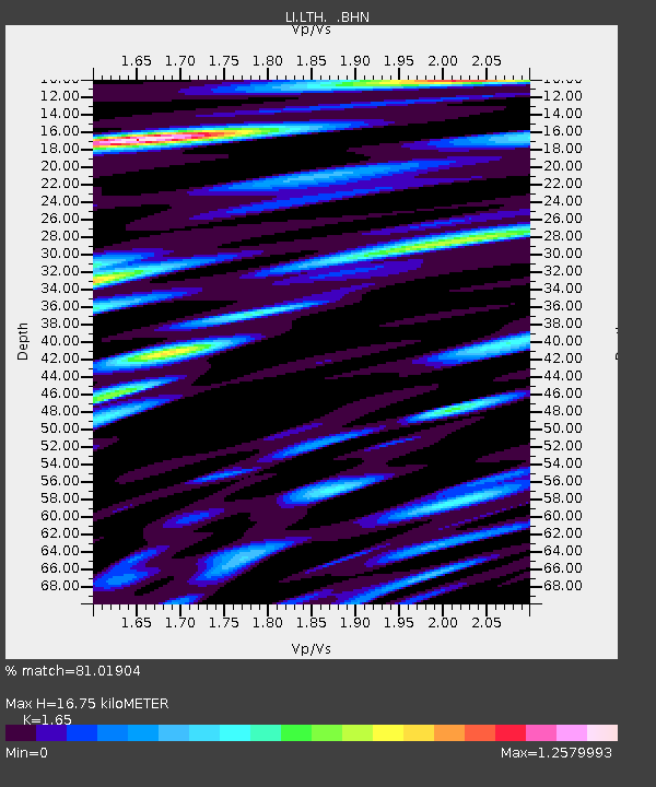
| Estimated Moho Depth: |
16.75 km |
| Estimated Crust Vp/Vs: |
1.65 |
| Assumed Crust Vp: |
6.419 km/s |
| Estimated Crust Vs: |
3.89 km/s |
| Estimated Crust Poisson's Ratio: |
0.21 |
|
| Radial Match: |
81.01904 % |
| Radial Bump: |
400 |
| Transverse Match: |
71.22841 % |
| Transverse Bump: |
400 |
| SOD ConfigId: |
2504 |
| Insert Time: |
2010-03-09 14:05:25.565 +0000 |
| GWidth: |
2.5 |
| Max Bumps: |
400 |
| Tol: |
0.001 |
|

Signal To Noise
| Channel | StoN | STA | LTA |
| LI:LTH: :BHN:20080715T03:39:11.090015Z | 6.1978703 | 9.825321E-7 | 1.5852737E-7 |
| LI:LTH: :BHE:20080715T03:39:11.090015Z | 1.7865634 | 3.8187198E-7 | 2.1374667E-7 |
| LI:LTH: :BHZ:20080715T03:39:11.090015Z | 1.3462013 | 2.2390934E-7 | 1.663268E-7 |
| Arrivals |
| Ps | 1.7 SECOND |
| PpPs | 6.8 SECOND |
| PsPs/PpSs | 8.5 SECOND |


