You are here: Home > Network List > UU - University of Utah Regional Network Stations List
> Station CCUT Cedar City, UT, USA > Earthquake Result Viewer
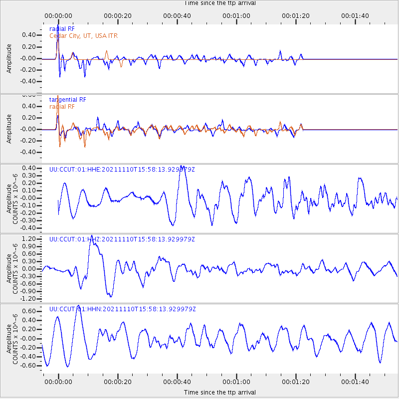
CCUT Cedar City, UT, USA - Earthquake Result Viewer
*The percent match for this event was below the threshold and hence no stack was calculated.
| Earthquake location: |
Southeast Of Ryukyu Islands |
| Earthquake latitude/longitude: |
23.5/126.5 |
| Earthquake time(UTC): |
2021/11/10 (314) 15:45:13 GMT |
| Earthquake Depth: |
10 km |
| Earthquake Magnitude: |
6.6 Mww |
| Earthquake Catalog/Contributor: |
NEIC PDE/us |
|
| Network: |
UU University of Utah Regional Network |
| Station: |
CCUT Cedar City, UT, USA |
| Lat/Lon: |
37.55 N/113.36 W |
| Elevation: |
2127 m |
|
| Distance: |
97.2 deg |
| Az: |
43.843 deg |
| Baz: |
306.885 deg |
| Ray Param: |
$rayparam |
*The percent match for this event was below the threshold and hence was not used in the summary stack. |
|
| Radial Match: |
55.048832 % |
| Radial Bump: |
400 |
| Transverse Match: |
46.26215 % |
| Transverse Bump: |
365 |
| SOD ConfigId: |
26694651 |
| Insert Time: |
2021-11-24 16:05:01.090 +0000 |
| GWidth: |
2.5 |
| Max Bumps: |
400 |
| Tol: |
0.001 |
|
Signal To Noise
| Channel | StoN | STA | LTA |
| UU:CCUT:01:HHZ:20211110T15:58:13.929979Z | 0.49047908 | 1.09539506E-7 | 2.2333165E-7 |
| UU:CCUT:01:HHN:20211110T15:58:13.929979Z | 2.0037234 | 4.0991324E-7 | 2.0457576E-7 |
| UU:CCUT:01:HHE:20211110T15:58:13.929979Z | 0.34502202 | 3.61118E-8 | 1.04665205E-7 |
| Arrivals |
| Ps | |
| PpPs | |
| PsPs/PpSs | |


