You are here: Home > Network List > LI - Laser Interferometer Gravitational-Wave Experiment (LIGO) Stations List
> Station LTH LTH, Bishop, CA, USA > Earthquake Result Viewer
LTH LTH, Bishop, CA, USA - Earthquake Result Viewer
| Earthquake location: |
Southern Bolivia |
| Earthquake latitude/longitude: |
-20.1/-65.0 |
| Earthquake time(UTC): |
2008/10/12 (286) 20:55:41 GMT |
| Earthquake Depth: |
353 km |
| Earthquake Magnitude: |
6.0 MB, 6.2 MW, 6.2 MW |
| Earthquake Catalog/Contributor: |
WHDF/NEIC |
|
| Network: |
LI Laser Interferometer Gravitational-Wave Experiment (LIGO) |
| Station: |
LTH LTH, Bishop, CA, USA |
| Lat/Lon: |
46.46 N/119.42 W |
| Elevation: |
157 m |
|
| Distance: |
82.5 deg |
| Az: |
325.441 deg |
| Baz: |
129.546 deg |
| Ray Param: |
0.04590918 |
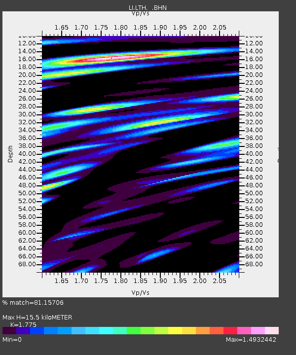
| Estimated Moho Depth: |
15.5 km |
| Estimated Crust Vp/Vs: |
1.77 |
| Assumed Crust Vp: |
6.419 km/s |
| Estimated Crust Vs: |
3.616 km/s |
| Estimated Crust Poisson's Ratio: |
0.27 |
|
| Radial Match: |
81.15706 % |
| Radial Bump: |
400 |
| Transverse Match: |
62.949028 % |
| Transverse Bump: |
400 |
| SOD ConfigId: |
2556 |
| Insert Time: |
2010-03-09 14:05:43.603 +0000 |
| GWidth: |
2.5 |
| Max Bumps: |
400 |
| Tol: |
0.001 |
|

Signal To Noise
| Channel | StoN | STA | LTA |
| LI:LTH: :BHN:20081012T21:06:54.223Z | 4.517881 | 8.2445416E-7 | 1.8248691E-7 |
| LI:LTH: :BHE:20081012T21:06:54.225015Z | 1.7155869 | 2.226456E-7 | 1.2977809E-7 |
| LI:LTH: :BHZ:20081012T21:06:54.22001Z | 2.4213445 | 2.7557599E-7 | 1.1381114E-7 |
| Arrivals |
| Ps | 1.9 SECOND |
| PpPs | 6.5 SECOND |
| PsPs/PpSs | 8.5 SECOND |


