You are here: Home > Network List > AK - Alaska Regional Network Stations List
> Station G24K Hadweenzic River, AK, USA > Earthquake Result Viewer
G24K Hadweenzic River, AK, USA - Earthquake Result Viewer
| Earthquake location: |
Southern Iran |
| Earthquake latitude/longitude: |
27.7/56.1 |
| Earthquake time(UTC): |
2021/11/14 (318) 12:07:03 GMT |
| Earthquake Depth: |
7.0 km |
| Earthquake Magnitude: |
6.0 Mwb |
| Earthquake Catalog/Contributor: |
NEIC PDE/us |
|
| Network: |
AK Alaska Regional Network |
| Station: |
G24K Hadweenzic River, AK, USA |
| Lat/Lon: |
66.70 N/147.48 W |
| Elevation: |
503 m |
|
| Distance: |
84.2 deg |
| Az: |
9.189 deg |
| Baz: |
339.151 deg |
| Ray Param: |
0.045664214 |
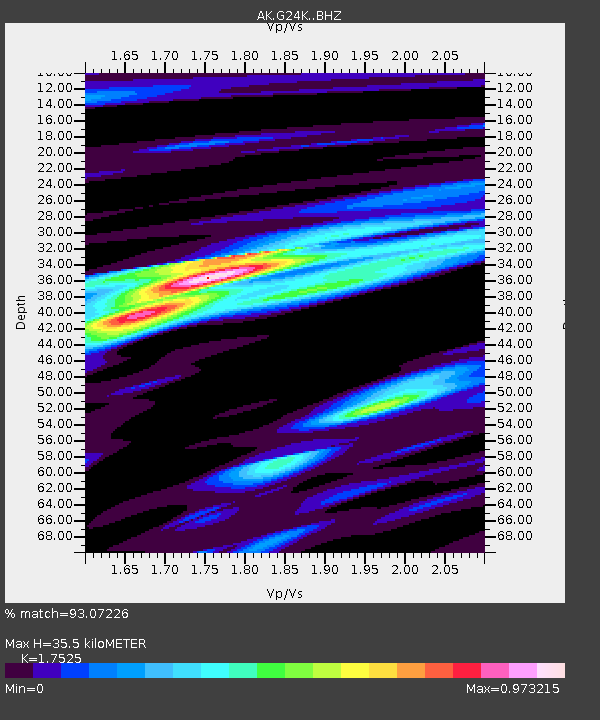
| Estimated Moho Depth: |
35.5 km |
| Estimated Crust Vp/Vs: |
1.75 |
| Assumed Crust Vp: |
6.522 km/s |
| Estimated Crust Vs: |
3.721 km/s |
| Estimated Crust Poisson's Ratio: |
0.26 |
|
| Radial Match: |
93.07226 % |
| Radial Bump: |
354 |
| Transverse Match: |
80.08717 % |
| Transverse Bump: |
394 |
| SOD ConfigId: |
26694651 |
| Insert Time: |
2021-11-28 12:09:27.134 +0000 |
| GWidth: |
2.5 |
| Max Bumps: |
400 |
| Tol: |
0.001 |
|

Signal To Noise
| Channel | StoN | STA | LTA |
| AK:G24K: :BHZ:20211114T12:19:03.88003Z | 11.629841 | 1.6166057E-6 | 1.3900497E-7 |
| AK:G24K: :BHN:20211114T12:19:03.88003Z | 3.721381 | 5.2699954E-7 | 1.4161397E-7 |
| AK:G24K: :BHE:20211114T12:19:03.88003Z | 1.084552 | 2.0766105E-7 | 1.9147173E-7 |
| Arrivals |
| Ps | 4.2 SECOND |
| PpPs | 15 SECOND |
| PsPs/PpSs | 19 SECOND |


