You are here: Home > Network List > AU - Australian Seismological Centre Stations List
> Station KIM01 GSWA station > Earthquake Result Viewer
KIM01 GSWA station - Earthquake Result Viewer
| Earthquake location: |
Southern Iran |
| Earthquake latitude/longitude: |
27.7/56.1 |
| Earthquake time(UTC): |
2021/11/14 (318) 12:07:03 GMT |
| Earthquake Depth: |
7.0 km |
| Earthquake Magnitude: |
6.0 Mwb |
| Earthquake Catalog/Contributor: |
NEIC PDE/us |
|
| Network: |
AU Australian Seismological Centre |
| Station: |
KIM01 GSWA station |
| Lat/Lon: |
18.62 S/126.86 E |
| Elevation: |
314 m |
|
| Distance: |
82.6 deg |
| Az: |
115.425 deg |
| Baz: |
302.402 deg |
| Ray Param: |
0.04681424 |
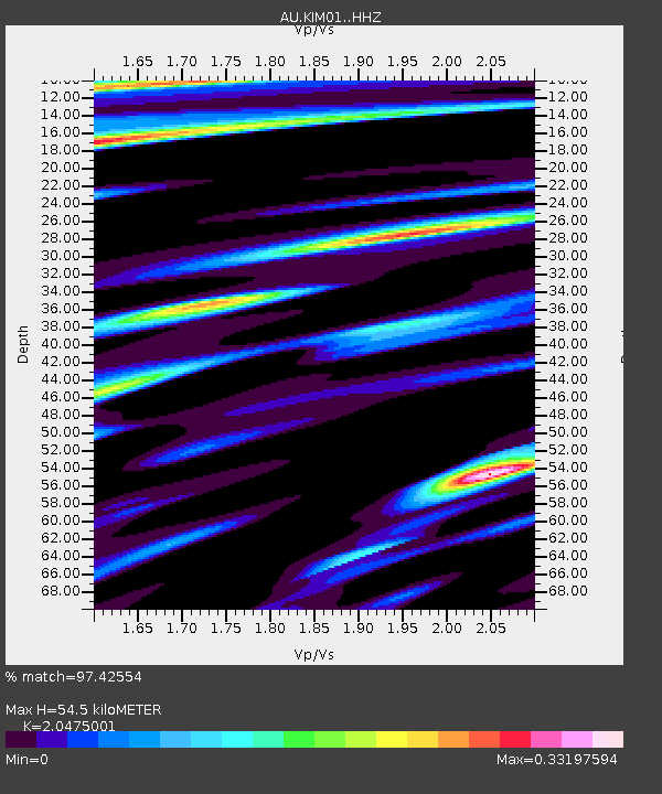
| Estimated Moho Depth: |
54.5 km |
| Estimated Crust Vp/Vs: |
2.05 |
| Assumed Crust Vp: |
6.496 km/s |
| Estimated Crust Vs: |
3.173 km/s |
| Estimated Crust Poisson's Ratio: |
0.34 |
|
| Radial Match: |
97.42554 % |
| Radial Bump: |
290 |
| Transverse Match: |
84.30658 % |
| Transverse Bump: |
400 |
| SOD ConfigId: |
26694651 |
| Insert Time: |
2021-11-28 12:12:55.834 +0000 |
| GWidth: |
2.5 |
| Max Bumps: |
400 |
| Tol: |
0.001 |
|

Signal To Noise
| Channel | StoN | STA | LTA |
| AU:KIM01: :HHZ:20211114T12:18:55.48501Z | 18.873684 | 1.1888886E-4 | 6.2991867E-6 |
| AU:KIM01: :HHN:20211114T12:18:55.48501Z | 3.9582005 | 3.6001722E-5 | 9.095477E-6 |
| AU:KIM01: :HHE:20211114T12:18:55.48501Z | 17.347591 | 8.371175E-5 | 4.8255542E-6 |
| Arrivals |
| Ps | 9.0 SECOND |
| PpPs | 25 SECOND |
| PsPs/PpSs | 34 SECOND |


