You are here: Home > Network List > AV - Alaska Volcano Observatory Stations List
> Station SPCR Ckakachatna River, Mount Spurr, Alaska > Earthquake Result Viewer
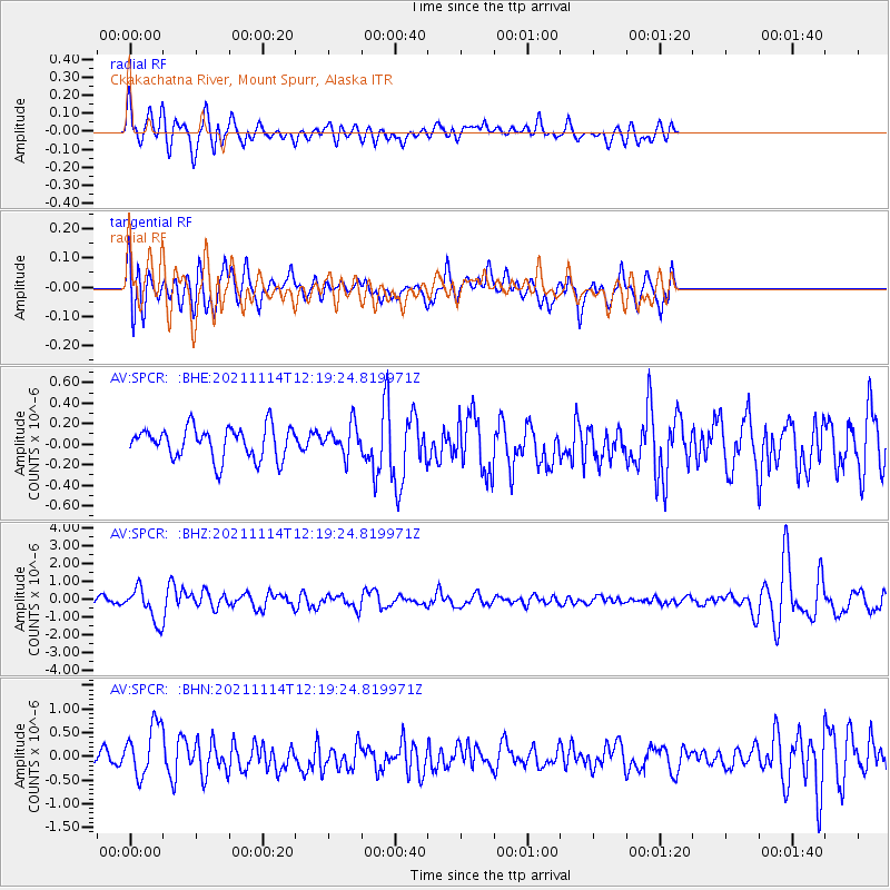
SPCR Ckakachatna River, Mount Spurr, Alaska - Earthquake Result Viewer
*The percent match for this event was below the threshold and hence no stack was calculated.
| Earthquake location: |
Southern Iran |
| Earthquake latitude/longitude: |
27.7/56.1 |
| Earthquake time(UTC): |
2021/11/14 (318) 12:07:03 GMT |
| Earthquake Depth: |
7.0 km |
| Earthquake Magnitude: |
6.0 Mwb |
| Earthquake Catalog/Contributor: |
NEIC PDE/us |
|
| Network: |
AV Alaska Volcano Observatory |
| Station: |
SPCR Ckakachatna River, Mount Spurr, Alaska |
| Lat/Lon: |
61.20 N/152.21 W |
| Elevation: |
984 m |
|
| Distance: |
88.5 deg |
| Az: |
13.265 deg |
| Baz: |
335.16 deg |
| Ray Param: |
$rayparam |
*The percent match for this event was below the threshold and hence was not used in the summary stack. |
|
| Radial Match: |
64.26128 % |
| Radial Bump: |
400 |
| Transverse Match: |
68.14953 % |
| Transverse Bump: |
400 |
| SOD ConfigId: |
26694651 |
| Insert Time: |
2021-11-28 12:14:32.501 +0000 |
| GWidth: |
2.5 |
| Max Bumps: |
400 |
| Tol: |
0.001 |
|
Signal To Noise
| Channel | StoN | STA | LTA |
| AV:SPCR: :BHZ:20211114T12:19:24.819971Z | 4.450748 | 9.270007E-7 | 2.0827976E-7 |
| AV:SPCR: :BHN:20211114T12:19:24.819971Z | 3.5777295 | 5.4200456E-7 | 1.51494E-7 |
| AV:SPCR: :BHE:20211114T12:19:24.819971Z | 0.93477374 | 1.4379789E-7 | 1.5383175E-7 |
| Arrivals |
| Ps | |
| PpPs | |
| PsPs/PpSs | |


