You are here: Home > Network List > BX - Botswana Seismological Network Stations List
> Station MAKGR Mmakgori > Earthquake Result Viewer
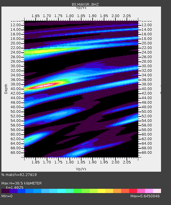
MAKGR Mmakgori - Earthquake Result Viewer
| Earthquake location: |
Southern Iran |
| Earthquake latitude/longitude: |
27.7/56.1 |
| Earthquake time(UTC): |
2021/11/14 (318) 12:07:03 GMT |
| Earthquake Depth: |
7.0 km |
| Earthquake Magnitude: |
6.0 Mwb |
| Earthquake Catalog/Contributor: |
NEIC PDE/us |
|
| Network: |
BX Botswana Seismological Network |
| Station: |
MAKGR Mmakgori |
| Lat/Lon: |
25.81 S/24.80 E |
| Elevation: |
1158 m |
|
| Distance: |
61.1 deg |
| Az: |
212.285 deg |
| Baz: |
31.69 deg |
| Ray Param: |
0.06108123 |
| Estimated Moho Depth: |
38.5 km |
| Estimated Crust Vp/Vs: |
1.68 |
| Assumed Crust Vp: |
6.459 km/s |
| Estimated Crust Vs: |
3.839 km/s |
| Estimated Crust Poisson's Ratio: |
0.23 |
|
| Radial Match: |
92.27619 % |
| Radial Bump: |
329 |
| Transverse Match: |
49.406532 % |
| Transverse Bump: |
400 |
| SOD ConfigId: |
26694651 |
| Insert Time: |
2021-11-28 12:15:10.834 +0000 |
| GWidth: |
2.5 |
| Max Bumps: |
400 |
| Tol: |
0.001 |
|

Signal To Noise
| Channel | StoN | STA | LTA |
| BX:MAKGR: :BHZ:20211114T12:16:47.269007Z | 10.675709 | 1.2000064E-6 | 1.1240532E-7 |
| BX:MAKGR: :BHN:20211114T12:16:47.269007Z | 5.484268 | 4.859728E-7 | 8.8612154E-8 |
| BX:MAKGR: :BHE:20211114T12:16:47.269007Z | 2.343982 | 3.889551E-7 | 1.6593775E-7 |
| Arrivals |
| Ps | 4.3 SECOND |
| PpPs | 15 SECOND |
| PsPs/PpSs | 19 SECOND |


