You are here: Home > Network List > NM - Cooperative New Madrid Seismic Network Stations List
> Station PARM Stahl Farm,MO > Earthquake Result Viewer
PARM Stahl Farm,MO - Earthquake Result Viewer
| Earthquake location: |
Easter Island Region |
| Earthquake latitude/longitude: |
-24.3/-112.1 |
| Earthquake time(UTC): |
2018/05/02 (122) 06:31:32 GMT |
| Earthquake Depth: |
10 km |
| Earthquake Magnitude: |
5.5 mb |
| Earthquake Catalog/Contributor: |
NEIC PDE/us |
|
| Network: |
NM Cooperative New Madrid Seismic Network |
| Station: |
PARM Stahl Farm,MO |
| Lat/Lon: |
36.66 N/89.75 W |
| Elevation: |
85 m |
|
| Distance: |
64.2 deg |
| Az: |
19.888 deg |
| Baz: |
202.713 deg |
| Ray Param: |
0.05908851 |
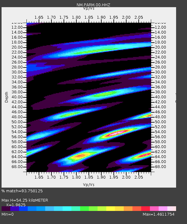
| Estimated Moho Depth: |
54.25 km |
| Estimated Crust Vp/Vs: |
1.96 |
| Assumed Crust Vp: |
6.444 km/s |
| Estimated Crust Vs: |
3.284 km/s |
| Estimated Crust Poisson's Ratio: |
0.32 |
|
| Radial Match: |
93.758125 % |
| Radial Bump: |
400 |
| Transverse Match: |
90.802956 % |
| Transverse Bump: |
400 |
| SOD ConfigId: |
2665671 |
| Insert Time: |
2018-05-16 06:38:48.421 +0000 |
| GWidth: |
2.5 |
| Max Bumps: |
400 |
| Tol: |
0.001 |
|

Signal To Noise
| Channel | StoN | STA | LTA |
| NM:PARM:00:HHZ:20180502T06:41:36.104993Z | 2.4668355 | 1.0453939E-6 | 4.2377934E-7 |
| NM:PARM:00:HHN:20180502T06:41:36.104993Z | 2.1813066 | 1.2396374E-6 | 5.6830044E-7 |
| NM:PARM:00:HHE:20180502T06:41:36.104993Z | 2.7633483 | 8.5612623E-7 | 3.0981482E-7 |
| Arrivals |
| Ps | 8.4 SECOND |
| PpPs | 24 SECOND |
| PsPs/PpSs | 32 SECOND |


