You are here: Home > Network List > CN - Canadian National Seismograph Network Stations List
> Station INK INUVIK, NT > Earthquake Result Viewer
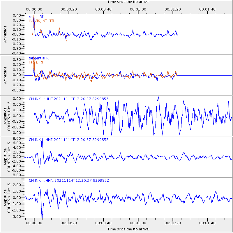
INK INUVIK, NT - Earthquake Result Viewer
*The percent match for this event was below the threshold and hence no stack was calculated.
| Earthquake location: |
Southern Iran |
| Earthquake latitude/longitude: |
27.7/56.1 |
| Earthquake time(UTC): |
2021/11/14 (318) 12:08:38 GMT |
| Earthquake Depth: |
10 km |
| Earthquake Magnitude: |
6.3 mb |
| Earthquake Catalog/Contributor: |
NEIC PDE/us |
|
| Network: |
CN Canadian National Seismograph Network |
| Station: |
INK INUVIK, NT |
| Lat/Lon: |
68.31 N/133.53 W |
| Elevation: |
44 m |
|
| Distance: |
84.0 deg |
| Az: |
3.575 deg |
| Baz: |
351.45 deg |
| Ray Param: |
$rayparam |
*The percent match for this event was below the threshold and hence was not used in the summary stack. |
|
| Radial Match: |
75.82326 % |
| Radial Bump: |
379 |
| Transverse Match: |
78.10024 % |
| Transverse Bump: |
400 |
| SOD ConfigId: |
26694651 |
| Insert Time: |
2021-11-28 12:30:54.800 +0000 |
| GWidth: |
2.5 |
| Max Bumps: |
400 |
| Tol: |
0.001 |
|
Signal To Noise
| Channel | StoN | STA | LTA |
| CN:INK: :HHZ:20211114T12:20:37.829985Z | 7.2840934 | 3.2437863E-6 | 4.4532464E-7 |
| CN:INK: :HHN:20211114T12:20:37.829985Z | 5.6662946 | 1.1884509E-6 | 2.097404E-7 |
| CN:INK: :HHE:20211114T12:20:37.829985Z | 2.0976589 | 3.8841225E-7 | 1.8516465E-7 |
| Arrivals |
| Ps | |
| PpPs | |
| PsPs/PpSs | |


