You are here: Home > Network List > G - GEOSCOPE Stations List
> Station RER Riviere de l'Est, La Reunion (Indian Ocean) > Earthquake Result Viewer
RER Riviere de l'Est, La Reunion (Indian Ocean) - Earthquake Result Viewer
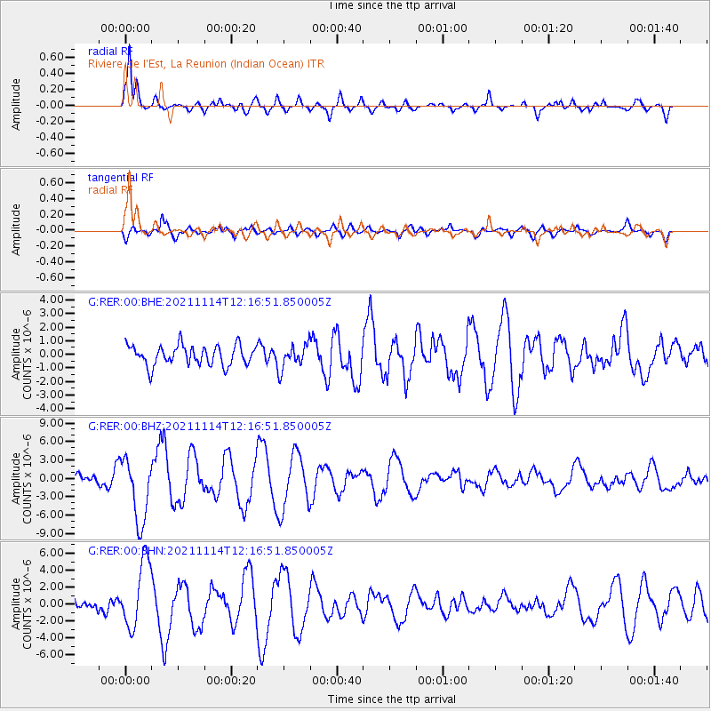
| Earthquake location: |
Southern Iran |
| Earthquake latitude/longitude: |
27.7/56.1 |
| Earthquake time(UTC): |
2021/11/14 (318) 12:08:38 GMT |
| Earthquake Depth: |
10 km |
| Earthquake Magnitude: |
6.3 mb |
| Earthquake Catalog/Contributor: |
NEIC PDE/us |
|
| Network: |
G GEOSCOPE |
| Station: |
RER Riviere de l'Est, La Reunion (Indian Ocean) |
| Lat/Lon: |
21.16 S/55.75 E |
| Elevation: |
834 m |
|
| Distance: |
48.6 deg |
| Az: |
180.411 deg |
| Baz: |
0.391 deg |
| Ray Param: |
0.06925504 |
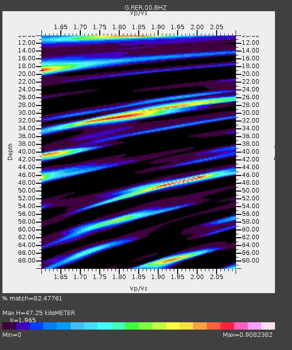
| Estimated Moho Depth: |
47.25 km |
| Estimated Crust Vp/Vs: |
1.97 |
| Assumed Crust Vp: |
4.73 km/s |
| Estimated Crust Vs: |
2.407 km/s |
| Estimated Crust Poisson's Ratio: |
0.33 |
|
| Radial Match: |
82.47761 % |
| Radial Bump: |
350 |
| Transverse Match: |
56.827324 % |
| Transverse Bump: |
400 |
| SOD ConfigId: |
26694651 |
| Insert Time: |
2021-11-28 12:31:56.163 +0000 |
| GWidth: |
2.5 |
| Max Bumps: |
400 |
| Tol: |
0.001 |
|
Signal To Noise
| Channel | StoN | STA | LTA |
| G:RER:00:BHZ:20211114T12:16:51.850005Z | 5.467295 | 5.273185E-6 | 9.64496E-7 |
| G:RER:00:BHN:20211114T12:16:51.850005Z | 4.5658984 | 3.9995416E-6 | 8.759595E-7 |
| G:RER:00:BHE:20211114T12:16:51.850005Z | 1.2124726 | 8.8109334E-7 | 7.266913E-7 |
| Arrivals |
| Ps | 9.9 SECOND |
| PpPs | 29 SECOND |
| PsPs/PpSs | 39 SECOND |


