You are here: Home > Network List > OX - North-East Italy Seismic Network Stations List
> Station DRE Drenchia > Earthquake Result Viewer
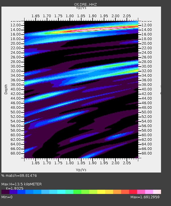
DRE Drenchia - Earthquake Result Viewer
| Earthquake location: |
Southern Iran |
| Earthquake latitude/longitude: |
27.7/56.1 |
| Earthquake time(UTC): |
2021/11/14 (318) 12:08:38 GMT |
| Earthquake Depth: |
10 km |
| Earthquake Magnitude: |
6.3 mb |
| Earthquake Catalog/Contributor: |
NEIC PDE/us |
|
| Network: |
OX North-East Italy Seismic Network |
| Station: |
DRE Drenchia |
| Lat/Lon: |
46.17 N/13.65 E |
| Elevation: |
810 m |
|
| Distance: |
38.0 deg |
| Az: |
310.466 deg |
| Baz: |
103.968 deg |
| Ray Param: |
0.07578946 |
| Estimated Moho Depth: |
13.5 km |
| Estimated Crust Vp/Vs: |
1.93 |
| Assumed Crust Vp: |
6.35 km/s |
| Estimated Crust Vs: |
3.286 km/s |
| Estimated Crust Poisson's Ratio: |
0.32 |
|
| Radial Match: |
89.81476 % |
| Radial Bump: |
400 |
| Transverse Match: |
74.21701 % |
| Transverse Bump: |
400 |
| SOD ConfigId: |
26694651 |
| Insert Time: |
2021-11-28 12:35:10.246 +0000 |
| GWidth: |
2.5 |
| Max Bumps: |
400 |
| Tol: |
0.001 |
|

Signal To Noise
| Channel | StoN | STA | LTA |
| OX:DRE: :HHZ:20211114T12:15:26.589995Z | 8.594093 | 3.979324E-6 | 4.6303012E-7 |
| OX:DRE: :HHN:20211114T12:15:26.589995Z | 3.146412 | 1.1361296E-6 | 3.6108736E-7 |
| OX:DRE: :HHE:20211114T12:15:26.589995Z | 6.0890765 | 2.8972229E-6 | 4.7580662E-7 |
| Arrivals |
| Ps | 2.1 SECOND |
| PpPs | 5.8 SECOND |
| PsPs/PpSs | 8.0 SECOND |


