You are here: Home > Network List > AK - Alaska Regional Network Stations List
> Station A21K Barrow, AK, USA > Earthquake Result Viewer
A21K Barrow, AK, USA - Earthquake Result Viewer
| Earthquake location: |
New Ireland Region, P.N.G. |
| Earthquake latitude/longitude: |
-5.3/153.7 |
| Earthquake time(UTC): |
2021/11/18 (322) 14:08:05 GMT |
| Earthquake Depth: |
35 km |
| Earthquake Magnitude: |
6.2 mww |
| Earthquake Catalog/Contributor: |
NEIC PDE/us |
|
| Network: |
AK Alaska Regional Network |
| Station: |
A21K Barrow, AK, USA |
| Lat/Lon: |
71.32 N/156.62 W |
| Elevation: |
5.0 m |
|
| Distance: |
83.1 deg |
| Az: |
14.32 deg |
| Baz: |
229.855 deg |
| Ray Param: |
0.046401963 |
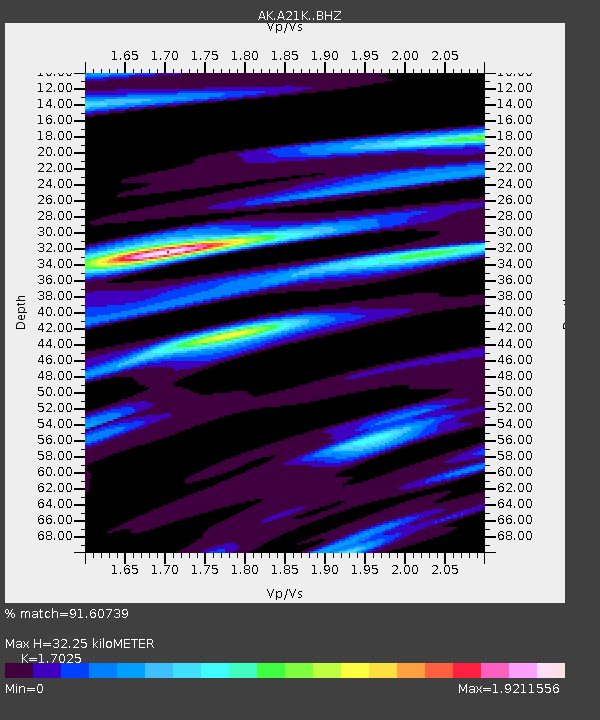
| Estimated Moho Depth: |
32.25 km |
| Estimated Crust Vp/Vs: |
1.70 |
| Assumed Crust Vp: |
6.048 km/s |
| Estimated Crust Vs: |
3.552 km/s |
| Estimated Crust Poisson's Ratio: |
0.24 |
|
| Radial Match: |
91.60739 % |
| Radial Bump: |
334 |
| Transverse Match: |
88.54373 % |
| Transverse Bump: |
400 |
| SOD ConfigId: |
26694651 |
| Insert Time: |
2021-12-02 14:09:09.398 +0000 |
| GWidth: |
2.5 |
| Max Bumps: |
400 |
| Tol: |
0.001 |
|

Signal To Noise
| Channel | StoN | STA | LTA |
| AK:A21K: :BHZ:20211118T14:19:55.920009Z | 15.028547 | 1.5282038E-6 | 1.0168673E-7 |
| AK:A21K: :BHN:20211118T14:19:55.920009Z | 5.060051 | 5.913544E-7 | 1.1686729E-7 |
| AK:A21K: :BHE:20211118T14:19:55.920009Z | 2.0151148 | 4.11305E-7 | 2.0410995E-7 |
| Arrivals |
| Ps | 3.8 SECOND |
| PpPs | 14 SECOND |
| PsPs/PpSs | 18 SECOND |


