You are here: Home > Network List > AK - Alaska Regional Network Stations List
> Station M14K Bethel, AK, USA > Earthquake Result Viewer
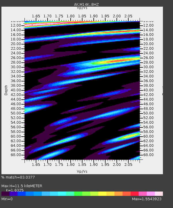
M14K Bethel, AK, USA - Earthquake Result Viewer
| Earthquake location: |
New Ireland Region, P.N.G. |
| Earthquake latitude/longitude: |
-5.3/153.7 |
| Earthquake time(UTC): |
2021/11/18 (322) 14:08:05 GMT |
| Earthquake Depth: |
35 km |
| Earthquake Magnitude: |
6.2 mww |
| Earthquake Catalog/Contributor: |
NEIC PDE/us |
|
| Network: |
AK Alaska Regional Network |
| Station: |
M14K Bethel, AK, USA |
| Lat/Lon: |
60.75 N/161.96 W |
| Elevation: |
19 m |
|
| Distance: |
74.3 deg |
| Az: |
20.869 deg |
| Baz: |
226.244 deg |
| Ray Param: |
0.052355062 |
| Estimated Moho Depth: |
11.5 km |
| Estimated Crust Vp/Vs: |
1.63 |
| Assumed Crust Vp: |
6.182 km/s |
| Estimated Crust Vs: |
3.787 km/s |
| Estimated Crust Poisson's Ratio: |
0.20 |
|
| Radial Match: |
83.0377 % |
| Radial Bump: |
400 |
| Transverse Match: |
70.34981 % |
| Transverse Bump: |
400 |
| SOD ConfigId: |
26694651 |
| Insert Time: |
2021-12-02 14:11:34.888 +0000 |
| GWidth: |
2.5 |
| Max Bumps: |
400 |
| Tol: |
0.001 |
|

Signal To Noise
| Channel | StoN | STA | LTA |
| AK:M14K: :BHZ:20211118T14:19:08.139979Z | 5.045761 | 2.1526655E-6 | 4.2662853E-7 |
| AK:M14K: :BHN:20211118T14:19:08.139979Z | 1.4805838 | 6.872206E-7 | 4.6415516E-7 |
| AK:M14K: :BHE:20211118T14:19:08.139979Z | 1.7666389 | 8.710597E-7 | 4.930604E-7 |
| Arrivals |
| Ps | 1.2 SECOND |
| PpPs | 4.7 SECOND |
| PsPs/PpSs | 6.0 SECOND |


