You are here: Home > Network List > AV - Alaska Volcano Observatory Stations List
> Station SPCR Ckakachatna River, Mount Spurr, Alaska > Earthquake Result Viewer
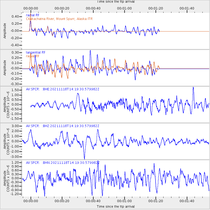
SPCR Ckakachatna River, Mount Spurr, Alaska - Earthquake Result Viewer
*The percent match for this event was below the threshold and hence no stack was calculated.
| Earthquake location: |
New Ireland Region, P.N.G. |
| Earthquake latitude/longitude: |
-5.3/153.7 |
| Earthquake time(UTC): |
2021/11/18 (322) 14:08:05 GMT |
| Earthquake Depth: |
35 km |
| Earthquake Magnitude: |
6.2 mww |
| Earthquake Catalog/Contributor: |
NEIC PDE/us |
|
| Network: |
AV Alaska Volcano Observatory |
| Station: |
SPCR Ckakachatna River, Mount Spurr, Alaska |
| Lat/Lon: |
61.20 N/152.21 W |
| Elevation: |
984 m |
|
| Distance: |
78.3 deg |
| Az: |
23.599 deg |
| Baz: |
235.407 deg |
| Ray Param: |
$rayparam |
*The percent match for this event was below the threshold and hence was not used in the summary stack. |
|
| Radial Match: |
70.99461 % |
| Radial Bump: |
400 |
| Transverse Match: |
67.72054 % |
| Transverse Bump: |
400 |
| SOD ConfigId: |
26694651 |
| Insert Time: |
2021-12-02 14:16:33.994 +0000 |
| GWidth: |
2.5 |
| Max Bumps: |
400 |
| Tol: |
0.001 |
|
Signal To Noise
| Channel | StoN | STA | LTA |
| AV:SPCR: :BHZ:20211118T14:19:30.579982Z | 4.991653 | 1.1690432E-6 | 2.3419963E-7 |
| AV:SPCR: :BHN:20211118T14:19:30.579982Z | 2.1698215 | 4.5771756E-7 | 2.109471E-7 |
| AV:SPCR: :BHE:20211118T14:19:30.579982Z | 3.4097283 | 6.520614E-7 | 1.9123559E-7 |
| Arrivals |
| Ps | |
| PpPs | |
| PsPs/PpSs | |


