You are here: Home > Network List > CI - Caltech Regional Seismic Network Stations List
> Station MPM Manuel Prospect Mine, California, USA > Earthquake Result Viewer
MPM Manuel Prospect Mine, California, USA - Earthquake Result Viewer
*The percent match for this event was below the threshold and hence no stack was calculated.
| Earthquake location: |
New Ireland Region, P.N.G. |
| Earthquake latitude/longitude: |
-5.3/153.7 |
| Earthquake time(UTC): |
2021/11/18 (322) 14:08:05 GMT |
| Earthquake Depth: |
35 km |
| Earthquake Magnitude: |
6.2 mww |
| Earthquake Catalog/Contributor: |
NEIC PDE/us |
|
| Network: |
CI Caltech Regional Seismic Network |
| Station: |
MPM Manuel Prospect Mine, California, USA |
| Lat/Lon: |
36.06 N/117.49 W |
| Elevation: |
185 m |
|
| Distance: |
92.1 deg |
| Az: |
54.16 deg |
| Baz: |
265.005 deg |
| Ray Param: |
$rayparam |
*The percent match for this event was below the threshold and hence was not used in the summary stack. |
|
| Radial Match: |
71.99337 % |
| Radial Bump: |
400 |
| Transverse Match: |
46.620716 % |
| Transverse Bump: |
400 |
| SOD ConfigId: |
26694651 |
| Insert Time: |
2021-12-02 14:20:09.381 +0000 |
| GWidth: |
2.5 |
| Max Bumps: |
400 |
| Tol: |
0.001 |
|
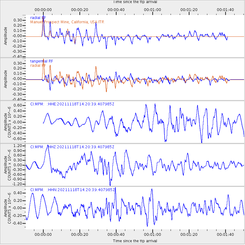
Signal To Noise
| Channel | StoN | STA | LTA |
| CI:MPM: :HHZ:20211118T14:20:39.407985Z | 5.9825644 | 6.914826E-7 | 1.1558298E-7 |
| CI:MPM: :HHN:20211118T14:20:39.407985Z | 1.2903044 | 2.1597684E-7 | 1.673844E-7 |
| CI:MPM: :HHE:20211118T14:20:39.407985Z | 1.7484394 | 1.9752068E-7 | 1.1296971E-7 |
| Arrivals |
| Ps | |
| PpPs | |
| PsPs/PpSs | |


