You are here: Home > Network List > IU - Global Seismograph Network (GSN - IRIS/USGS) Stations List
> Station JOHN Johnston Island, USA > Earthquake Result Viewer
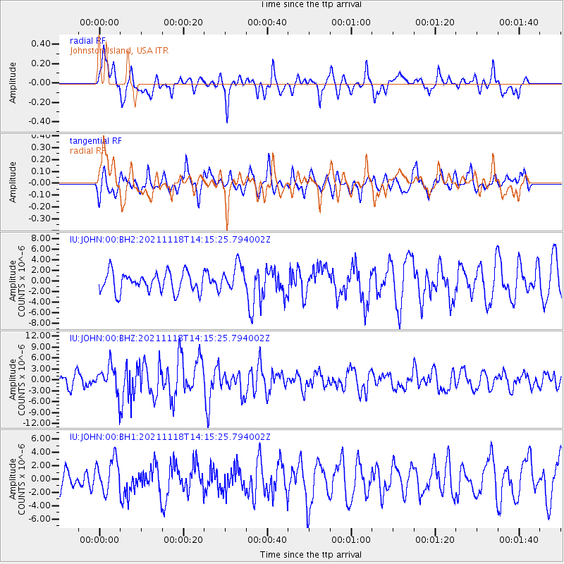
JOHN Johnston Island, USA - Earthquake Result Viewer
*The percent match for this event was below the threshold and hence no stack was calculated.
| Earthquake location: |
New Ireland Region, P.N.G. |
| Earthquake latitude/longitude: |
-5.3/153.7 |
| Earthquake time(UTC): |
2021/11/18 (322) 14:08:05 GMT |
| Earthquake Depth: |
35 km |
| Earthquake Magnitude: |
6.2 mww |
| Earthquake Catalog/Contributor: |
NEIC PDE/us |
|
| Network: |
IU Global Seismograph Network (GSN - IRIS/USGS) |
| Station: |
JOHN Johnston Island, USA |
| Lat/Lon: |
16.73 N/169.53 W |
| Elevation: |
2.0 m |
|
| Distance: |
42.4 deg |
| Az: |
58.183 deg |
| Baz: |
242.014 deg |
| Ray Param: |
$rayparam |
*The percent match for this event was below the threshold and hence was not used in the summary stack. |
|
| Radial Match: |
73.75527 % |
| Radial Bump: |
383 |
| Transverse Match: |
58.617565 % |
| Transverse Bump: |
400 |
| SOD ConfigId: |
26694651 |
| Insert Time: |
2021-12-02 14:23:49.599 +0000 |
| GWidth: |
2.5 |
| Max Bumps: |
400 |
| Tol: |
0.001 |
|
Signal To Noise
| Channel | StoN | STA | LTA |
| IU:JOHN:00:BHZ:20211118T14:15:25.794002Z | 2.218666 | 3.8120463E-6 | 1.7181703E-6 |
| IU:JOHN:00:BH1:20211118T14:15:25.794002Z | 0.9643905 | 2.4971519E-6 | 2.5893573E-6 |
| IU:JOHN:00:BH2:20211118T14:15:25.794002Z | 1.3570111 | 2.513701E-6 | 1.8523806E-6 |
| Arrivals |
| Ps | |
| PpPs | |
| PsPs/PpSs | |


