You are here: Home > Network List > TA - USArray Transportable Network (new EarthScope stations) Stations List
> Station TOLK Toolik Lake Research Station, AK, USA > Earthquake Result Viewer
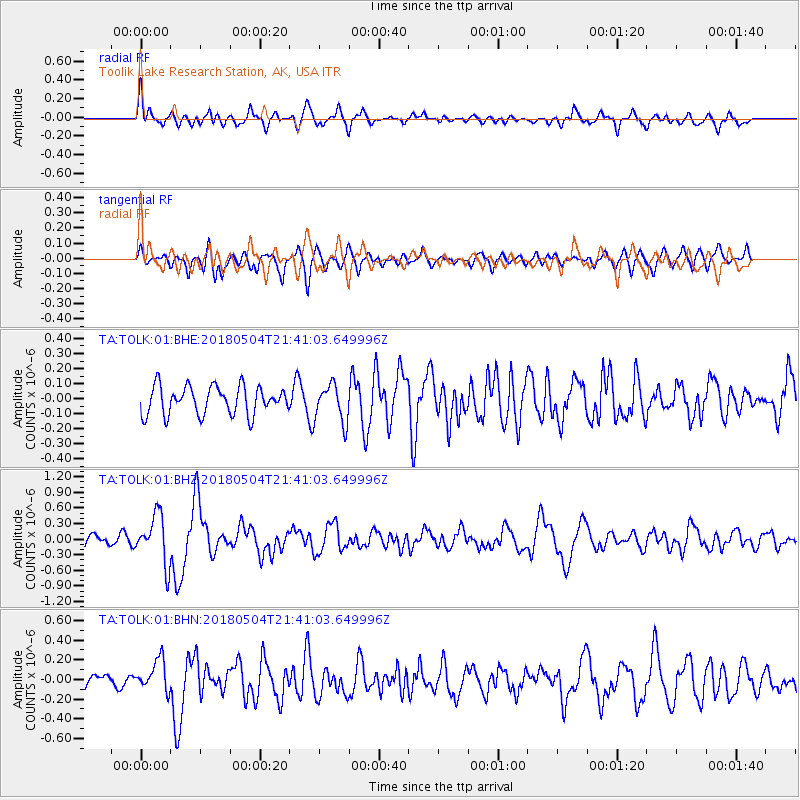
TOLK Toolik Lake Research Station, AK, USA - Earthquake Result Viewer
*The percent match for this event was below the threshold and hence no stack was calculated.
| Earthquake location: |
Hawaii |
| Earthquake latitude/longitude: |
19.3/-155.0 |
| Earthquake time(UTC): |
2018/05/04 (124) 21:32:44 GMT |
| Earthquake Depth: |
6.9 km |
| Earthquake Magnitude: |
5.7 Ml |
| Earthquake Catalog/Contributor: |
NEIC PDE/hv |
|
| Network: |
TA USArray Transportable Network (new EarthScope stations) |
| Station: |
TOLK Toolik Lake Research Station, AK, USA |
| Lat/Lon: |
68.64 N/149.57 W |
| Elevation: |
760 m |
|
| Distance: |
49.4 deg |
| Az: |
2.631 deg |
| Baz: |
186.795 deg |
| Ray Param: |
$rayparam |
*The percent match for this event was below the threshold and hence was not used in the summary stack. |
|
| Radial Match: |
75.585495 % |
| Radial Bump: |
400 |
| Transverse Match: |
55.439514 % |
| Transverse Bump: |
400 |
| SOD ConfigId: |
2665671 |
| Insert Time: |
2018-05-18 21:38:06.706 +0000 |
| GWidth: |
2.5 |
| Max Bumps: |
400 |
| Tol: |
0.001 |
|
Signal To Noise
| Channel | StoN | STA | LTA |
| TA:TOLK:01:BHZ:20180504T21:41:03.649996Z | 3.9861255 | 4.6826557E-7 | 1.1747386E-7 |
| TA:TOLK:01:BHN:20180504T21:41:03.649996Z | 1.9648415 | 1.5967115E-7 | 8.126413E-8 |
| TA:TOLK:01:BHE:20180504T21:41:03.649996Z | 1.3343214 | 1.2376941E-7 | 9.275833E-8 |
| Arrivals |
| Ps | |
| PpPs | |
| PsPs/PpSs | |


