You are here: Home > Network List > UW - Pacific Northwest Regional Seismic Network Stations List
> Station LTY Liberty (broad-band) > Earthquake Result Viewer
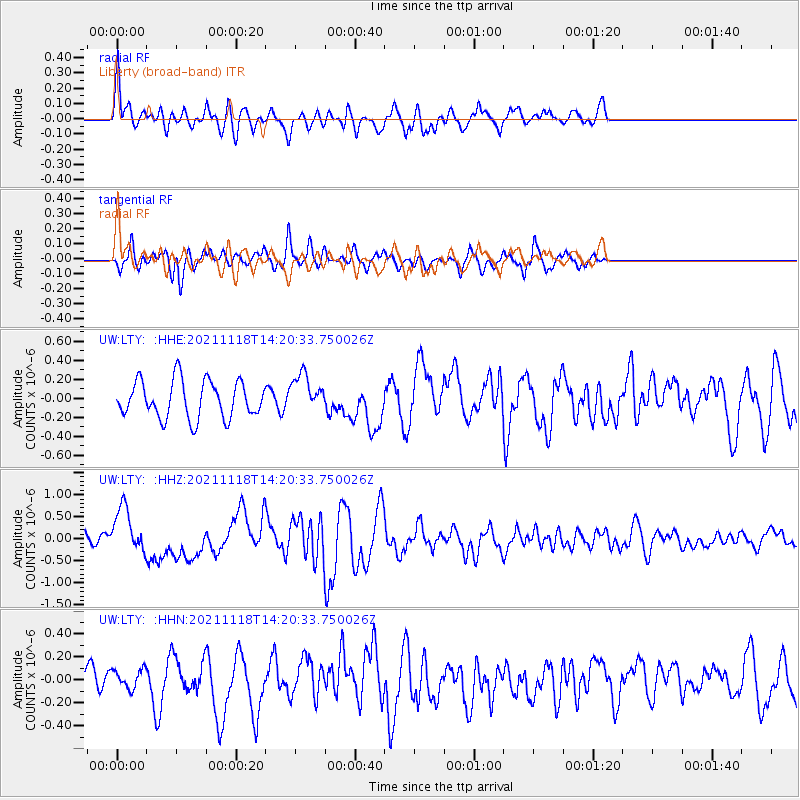
LTY Liberty (broad-band) - Earthquake Result Viewer
*The percent match for this event was below the threshold and hence no stack was calculated.
| Earthquake location: |
New Ireland Region, P.N.G. |
| Earthquake latitude/longitude: |
-5.3/153.7 |
| Earthquake time(UTC): |
2021/11/18 (322) 14:08:05 GMT |
| Earthquake Depth: |
35 km |
| Earthquake Magnitude: |
6.2 mww |
| Earthquake Catalog/Contributor: |
NEIC PDE/us |
|
| Network: |
UW Pacific Northwest Regional Seismic Network |
| Station: |
LTY Liberty (broad-band) |
| Lat/Lon: |
47.26 N/120.66 W |
| Elevation: |
970 m |
|
| Distance: |
90.9 deg |
| Az: |
42.785 deg |
| Baz: |
263.188 deg |
| Ray Param: |
$rayparam |
*The percent match for this event was below the threshold and hence was not used in the summary stack. |
|
| Radial Match: |
60.500534 % |
| Radial Bump: |
400 |
| Transverse Match: |
55.416153 % |
| Transverse Bump: |
400 |
| SOD ConfigId: |
26694651 |
| Insert Time: |
2021-12-02 14:31:15.609 +0000 |
| GWidth: |
2.5 |
| Max Bumps: |
400 |
| Tol: |
0.001 |
|
Signal To Noise
| Channel | StoN | STA | LTA |
| UW:LTY: :HHZ:20211118T14:20:33.750026Z | 3.9564757 | 5.1814055E-7 | 1.3096013E-7 |
| UW:LTY: :HHN:20211118T14:20:33.750026Z | 0.45134008 | 8.124289E-8 | 1.8000371E-7 |
| UW:LTY: :HHE:20211118T14:20:33.750026Z | 1.0309712 | 2.0136608E-7 | 1.9531689E-7 |
| Arrivals |
| Ps | |
| PpPs | |
| PsPs/PpSs | |


