You are here: Home > Network List > US - United States National Seismic Network Stations List
> Station MSO Missoula, Montana, USA > Earthquake Result Viewer
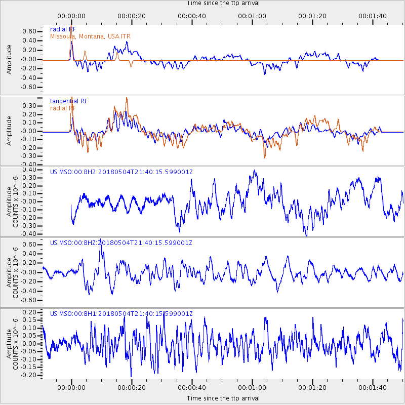
MSO Missoula, Montana, USA - Earthquake Result Viewer
*The percent match for this event was below the threshold and hence no stack was calculated.
| Earthquake location: |
Hawaii |
| Earthquake latitude/longitude: |
19.3/-155.0 |
| Earthquake time(UTC): |
2018/05/04 (124) 21:32:44 GMT |
| Earthquake Depth: |
6.9 km |
| Earthquake Magnitude: |
5.7 Ml |
| Earthquake Catalog/Contributor: |
NEIC PDE/hv |
|
| Network: |
US United States National Seismic Network |
| Station: |
MSO Missoula, Montana, USA |
| Lat/Lon: |
46.83 N/113.94 W |
| Elevation: |
1264 m |
|
| Distance: |
43.3 deg |
| Az: |
41.166 deg |
| Baz: |
244.854 deg |
| Ray Param: |
$rayparam |
*The percent match for this event was below the threshold and hence was not used in the summary stack. |
|
| Radial Match: |
47.372807 % |
| Radial Bump: |
400 |
| Transverse Match: |
50.55513 % |
| Transverse Bump: |
400 |
| SOD ConfigId: |
2665671 |
| Insert Time: |
2018-05-18 21:39:28.556 +0000 |
| GWidth: |
2.5 |
| Max Bumps: |
400 |
| Tol: |
0.001 |
|
Signal To Noise
| Channel | StoN | STA | LTA |
| US:MSO:00:BHZ:20180504T21:40:15.599001Z | 2.7031436 | 1.5410811E-7 | 5.70107E-8 |
| US:MSO:00:BH1:20180504T21:40:15.599001Z | 1.1253669 | 4.5746066E-8 | 4.0649912E-8 |
| US:MSO:00:BH2:20180504T21:40:15.599001Z | 1.3264643 | 1.0105621E-7 | 7.618464E-8 |
| Arrivals |
| Ps | |
| PpPs | |
| PsPs/PpSs | |


