You are here: Home > Network List > IW - Intermountain West Stations List
> Station PLID Pearl Lake, Idaho, USA > Earthquake Result Viewer
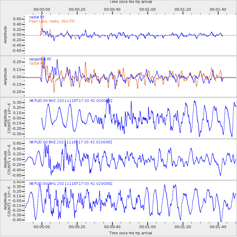
PLID Pearl Lake, Idaho, USA - Earthquake Result Viewer
*The percent match for this event was below the threshold and hence no stack was calculated.
| Earthquake location: |
Near Coast Of Guatemala |
| Earthquake latitude/longitude: |
13.6/-90.8 |
| Earthquake time(UTC): |
2021/11/18 (322) 16:56:56 GMT |
| Earthquake Depth: |
30 km |
| Earthquake Magnitude: |
5.8 Mww |
| Earthquake Catalog/Contributor: |
NEIC PDE/us |
|
| Network: |
IW Intermountain West |
| Station: |
PLID Pearl Lake, Idaho, USA |
| Lat/Lon: |
45.09 N/116.00 W |
| Elevation: |
2164 m |
|
| Distance: |
38.0 deg |
| Az: |
330.686 deg |
| Baz: |
137.768 deg |
| Ray Param: |
$rayparam |
*The percent match for this event was below the threshold and hence was not used in the summary stack. |
|
| Radial Match: |
50.457943 % |
| Radial Bump: |
358 |
| Transverse Match: |
49.967384 % |
| Transverse Bump: |
400 |
| SOD ConfigId: |
26694651 |
| Insert Time: |
2021-12-02 17:06:52.849 +0000 |
| GWidth: |
2.5 |
| Max Bumps: |
400 |
| Tol: |
0.001 |
|
Signal To Noise
| Channel | StoN | STA | LTA |
| IW:PLID:00:BHZ:20211118T17:03:42.020008Z | 2.2704852 | 2.9401232E-7 | 1.2949316E-7 |
| IW:PLID:00:BH1:20211118T17:03:42.020008Z | 1.4610863 | 1.8874678E-7 | 1.2918251E-7 |
| IW:PLID:00:BH2:20211118T17:03:42.020008Z | 0.5078333 | 7.351258E-8 | 1.4475731E-7 |
| Arrivals |
| Ps | |
| PpPs | |
| PsPs/PpSs | |


