You are here: Home > Network List > UU - University of Utah Regional Network Stations List
> Station CCUT Cedar City, UT, USA > Earthquake Result Viewer
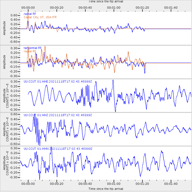
CCUT Cedar City, UT, USA - Earthquake Result Viewer
*The percent match for this event was below the threshold and hence no stack was calculated.
| Earthquake location: |
Near Coast Of Guatemala |
| Earthquake latitude/longitude: |
13.6/-90.8 |
| Earthquake time(UTC): |
2021/11/18 (322) 16:56:56 GMT |
| Earthquake Depth: |
30 km |
| Earthquake Magnitude: |
5.8 Mww |
| Earthquake Catalog/Contributor: |
NEIC PDE/us |
|
| Network: |
UU University of Utah Regional Network |
| Station: |
CCUT Cedar City, UT, USA |
| Lat/Lon: |
37.55 N/113.36 W |
| Elevation: |
2127 m |
|
| Distance: |
31.2 deg |
| Az: |
323.974 deg |
| Baz: |
133.972 deg |
| Ray Param: |
$rayparam |
*The percent match for this event was below the threshold and hence was not used in the summary stack. |
|
| Radial Match: |
55.880676 % |
| Radial Bump: |
400 |
| Transverse Match: |
47.298733 % |
| Transverse Bump: |
400 |
| SOD ConfigId: |
26694651 |
| Insert Time: |
2021-12-02 17:10:48.559 +0000 |
| GWidth: |
2.5 |
| Max Bumps: |
400 |
| Tol: |
0.001 |
|
Signal To Noise
| Channel | StoN | STA | LTA |
| UU:CCUT:01:HHZ:20211118T17:02:43.46999Z | 3.04728 | 2.2208759E-7 | 7.2880596E-8 |
| UU:CCUT:01:HHN:20211118T17:02:43.46999Z | 0.6662627 | 7.243323E-8 | 1.08715724E-7 |
| UU:CCUT:01:HHE:20211118T17:02:43.46999Z | 0.7938017 | 8.775782E-8 | 1.1055383E-7 |
| Arrivals |
| Ps | |
| PpPs | |
| PsPs/PpSs | |


