You are here: Home > Network List > CI - Caltech Regional Seismic Network Stations List
> Station MPM Manuel Prospect Mine, California, USA > Earthquake Result Viewer
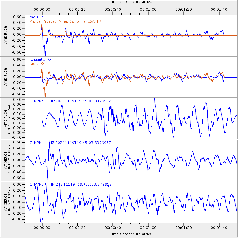
MPM Manuel Prospect Mine, California, USA - Earthquake Result Viewer
*The percent match for this event was below the threshold and hence no stack was calculated.
| Earthquake location: |
Vanuatu Islands |
| Earthquake latitude/longitude: |
-20.5/169.8 |
| Earthquake time(UTC): |
2021/11/19 (323) 19:32:56 GMT |
| Earthquake Depth: |
136 km |
| Earthquake Magnitude: |
5.6 mww |
| Earthquake Catalog/Contributor: |
NEIC PDE/us |
|
| Network: |
CI Caltech Regional Seismic Network |
| Station: |
MPM Manuel Prospect Mine, California, USA |
| Lat/Lon: |
36.06 N/117.49 W |
| Elevation: |
185 m |
|
| Distance: |
88.8 deg |
| Az: |
50.706 deg |
| Baz: |
243.538 deg |
| Ray Param: |
$rayparam |
*The percent match for this event was below the threshold and hence was not used in the summary stack. |
|
| Radial Match: |
70.141785 % |
| Radial Bump: |
357 |
| Transverse Match: |
39.34555 % |
| Transverse Bump: |
400 |
| SOD ConfigId: |
26694651 |
| Insert Time: |
2021-12-03 19:40:01.783 +0000 |
| GWidth: |
2.5 |
| Max Bumps: |
400 |
| Tol: |
0.001 |
|
Signal To Noise
| Channel | StoN | STA | LTA |
| CI:MPM: :HHZ:20211119T19:45:03.837995Z | 3.4362347 | 2.745757E-7 | 7.990598E-8 |
| CI:MPM: :HHN:20211119T19:45:03.837995Z | 2.4000702 | 2.2314585E-7 | 9.2974716E-8 |
| CI:MPM: :HHE:20211119T19:45:03.837995Z | 1.0812582 | 1.3358738E-7 | 1.2354809E-7 |
| Arrivals |
| Ps | |
| PpPs | |
| PsPs/PpSs | |


