You are here: Home > Network List > GS - US Geological Survey Networks Stations List
> Station KAN06 Argonia West Station > Earthquake Result Viewer
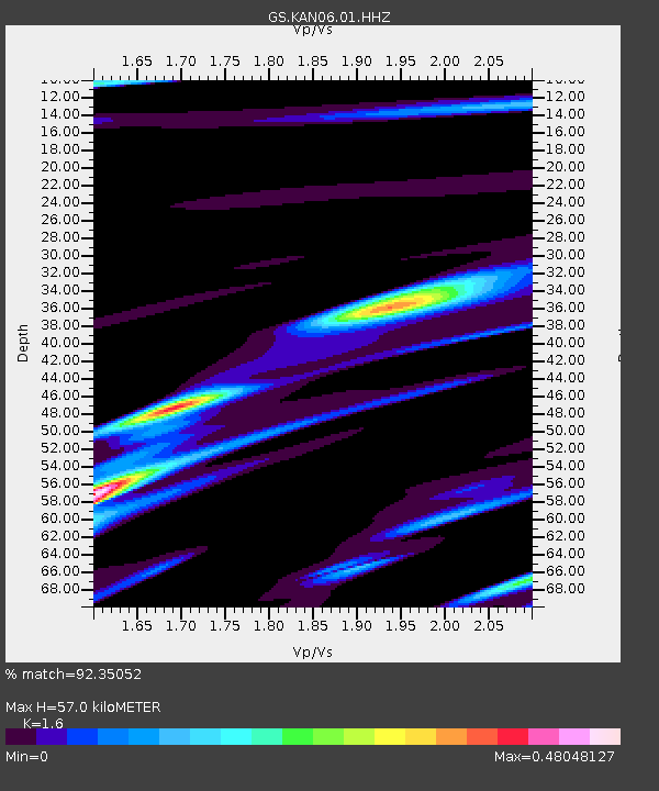
KAN06 Argonia West Station - Earthquake Result Viewer
| Earthquake location: |
Hawaii |
| Earthquake latitude/longitude: |
19.4/-155.0 |
| Earthquake time(UTC): |
2018/05/04 (124) 22:32:55 GMT |
| Earthquake Depth: |
5.0 km |
| Earthquake Magnitude: |
5.8 Ml |
| Earthquake Catalog/Contributor: |
NEIC PDE/us |
|
| Network: |
GS US Geological Survey Networks |
| Station: |
KAN06 Argonia West Station |
| Lat/Lon: |
37.25 N/97.86 W |
| Elevation: |
393 m |
|
| Distance: |
52.6 deg |
| Az: |
57.55 deg |
| Baz: |
266.727 deg |
| Ray Param: |
0.066655 |
| Estimated Moho Depth: |
57.0 km |
| Estimated Crust Vp/Vs: |
1.60 |
| Assumed Crust Vp: |
6.483 km/s |
| Estimated Crust Vs: |
4.052 km/s |
| Estimated Crust Poisson's Ratio: |
0.18 |
|
| Radial Match: |
92.35052 % |
| Radial Bump: |
294 |
| Transverse Match: |
60.82216 % |
| Transverse Bump: |
400 |
| SOD ConfigId: |
2665671 |
| Insert Time: |
2018-05-18 22:35:25.635 +0000 |
| GWidth: |
2.5 |
| Max Bumps: |
400 |
| Tol: |
0.001 |
|

Signal To Noise
| Channel | StoN | STA | LTA |
| GS:KAN06:01:HHZ:20180504T22:41:39.530029Z | 3.2976544 | 3.430404E-7 | 1.04025574E-7 |
| GS:KAN06:01:HHN:20180504T22:41:39.530029Z | 0.73633116 | 2.0473156E-7 | 2.7804276E-7 |
| GS:KAN06:01:HHE:20180504T22:41:39.530029Z | 1.8258004 | 2.7696956E-7 | 1.5169762E-7 |
| Arrivals |
| Ps | 5.6 SECOND |
| PpPs | 21 SECOND |
| PsPs/PpSs | 27 SECOND |


