You are here: Home > Network List > US - United States National Seismic Network Stations List
> Station MSO Missoula, Montana, USA > Earthquake Result Viewer
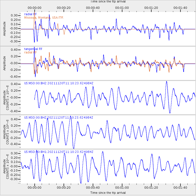
MSO Missoula, Montana, USA - Earthquake Result Viewer
*The percent match for this event was below the threshold and hence no stack was calculated.
| Earthquake location: |
Vanuatu Islands |
| Earthquake latitude/longitude: |
-15.6/167.6 |
| Earthquake time(UTC): |
2021/11/20 (324) 10:57:53 GMT |
| Earthquake Depth: |
129 km |
| Earthquake Magnitude: |
5.5 mww |
| Earthquake Catalog/Contributor: |
NEIC PDE/us |
|
| Network: |
US United States National Seismic Network |
| Station: |
MSO Missoula, Montana, USA |
| Lat/Lon: |
46.83 N/113.94 W |
| Elevation: |
1264 m |
|
| Distance: |
93.6 deg |
| Az: |
42.38 deg |
| Baz: |
251.082 deg |
| Ray Param: |
$rayparam |
*The percent match for this event was below the threshold and hence was not used in the summary stack. |
|
| Radial Match: |
60.845142 % |
| Radial Bump: |
400 |
| Transverse Match: |
64.98931 % |
| Transverse Bump: |
400 |
| SOD ConfigId: |
26694651 |
| Insert Time: |
2021-12-04 11:13:44.461 +0000 |
| GWidth: |
2.5 |
| Max Bumps: |
400 |
| Tol: |
0.001 |
|
Signal To Noise
| Channel | StoN | STA | LTA |
| US:MSO:00:BHZ:20211120T11:10:23.624984Z | 2.3961985 | 2.5205037E-7 | 1.0518759E-7 |
| US:MSO:00:BH1:20211120T11:10:23.624984Z | 2.1440804 | 2.518874E-7 | 1.1748038E-7 |
| US:MSO:00:BH2:20211120T11:10:23.624984Z | 1.0420952 | 1.3181064E-7 | 1.2648619E-7 |
| Arrivals |
| Ps | |
| PpPs | |
| PsPs/PpSs | |


