You are here: Home > Network List > US - United States National Seismic Network Stations List
> Station WUAZ Wupatki, Arizona, USA > Earthquake Result Viewer
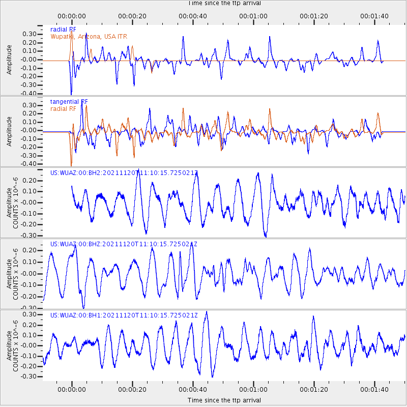
WUAZ Wupatki, Arizona, USA - Earthquake Result Viewer
*The percent match for this event was below the threshold and hence no stack was calculated.
| Earthquake location: |
Vanuatu Islands |
| Earthquake latitude/longitude: |
-15.6/167.6 |
| Earthquake time(UTC): |
2021/11/20 (324) 10:57:53 GMT |
| Earthquake Depth: |
129 km |
| Earthquake Magnitude: |
5.5 mww |
| Earthquake Catalog/Contributor: |
NEIC PDE/us |
|
| Network: |
US United States National Seismic Network |
| Station: |
WUAZ Wupatki, Arizona, USA |
| Lat/Lon: |
35.52 N/111.37 W |
| Elevation: |
1592 m |
|
| Distance: |
91.8 deg |
| Az: |
53.729 deg |
| Baz: |
252.238 deg |
| Ray Param: |
$rayparam |
*The percent match for this event was below the threshold and hence was not used in the summary stack. |
|
| Radial Match: |
61.719017 % |
| Radial Bump: |
400 |
| Transverse Match: |
48.166077 % |
| Transverse Bump: |
400 |
| SOD ConfigId: |
26694651 |
| Insert Time: |
2021-12-04 11:13:50.207 +0000 |
| GWidth: |
2.5 |
| Max Bumps: |
400 |
| Tol: |
0.001 |
|
Signal To Noise
| Channel | StoN | STA | LTA |
| US:WUAZ:00:BHZ:20211120T11:10:15.725021Z | 1.8710107 | 1.827642E-7 | 9.768207E-8 |
| US:WUAZ:00:BH1:20211120T11:10:15.725021Z | 0.53121716 | 4.7118192E-8 | 8.8698556E-8 |
| US:WUAZ:00:BH2:20211120T11:10:15.725021Z | 0.86407584 | 9.736154E-8 | 1.1267708E-7 |
| Arrivals |
| Ps | |
| PpPs | |
| PsPs/PpSs | |


