You are here: Home > Network List > XE99 - Broadband Experiment Across Alaskan Range Stations List
> Station RNDE Reindeer East > Earthquake Result Viewer
RNDE Reindeer East - Earthquake Result Viewer
| Earthquake location: |
Seram, Indonesia |
| Earthquake latitude/longitude: |
-4.0/127.3 |
| Earthquake time(UTC): |
2000/08/28 (241) 15:38:06 GMT |
| Earthquake Depth: |
10 km |
| Earthquake Magnitude: |
5.8 MB, 5.8 MS, 6.1 MW |
| Earthquake Catalog/Contributor: |
WHDF/NEIC |
|
| Network: |
XE Broadband Experiment Across Alaskan Range |
| Station: |
RNDE Reindeer East |
| Lat/Lon: |
63.40 N/148.82 W |
| Elevation: |
1109 m |
|
| Distance: |
90.8 deg |
| Az: |
26.591 deg |
| Baz: |
262.74 deg |
| Ray Param: |
0.041648936 |
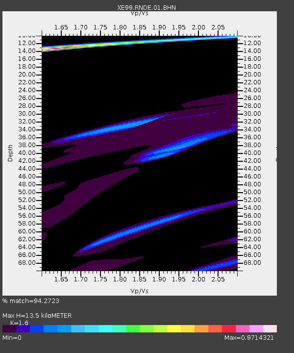
| Estimated Moho Depth: |
13.5 km |
| Estimated Crust Vp/Vs: |
1.60 |
| Assumed Crust Vp: |
6.566 km/s |
| Estimated Crust Vs: |
4.104 km/s |
| Estimated Crust Poisson's Ratio: |
0.18 |
|
| Radial Match: |
94.2723 % |
| Radial Bump: |
400 |
| Transverse Match: |
59.07406 % |
| Transverse Bump: |
400 |
| SOD ConfigId: |
3744 |
| Insert Time: |
2010-03-09 14:26:03.587 +0000 |
| GWidth: |
2.5 |
| Max Bumps: |
400 |
| Tol: |
0.001 |
|

Signal To Noise
| Channel | StoN | STA | LTA |
| XE:RNDE:01:BHN:20000828T15:50:38.015Z | 2.0482392 | 3.4035193E-6 | 1.6616805E-6 |
| XE:RNDE:01:BHE:20000828T15:50:38.015Z | 2.0634463 | 8.170867E-6 | 3.9598153E-6 |
| XE:RNDE:01:BHZ:20000828T15:50:38.015Z | 0.8591026 | 3.8504654E-6 | 4.4819626E-6 |
| Arrivals |
| Ps | 1.3 SECOND |
| PpPs | 5.2 SECOND |
| PsPs/PpSs | 6.5 SECOND |


