You are here: Home > Network List > TX - Texas Seismological Network Stations List
> Station SN01 Snyder 1 > Earthquake Result Viewer
SN01 Snyder 1 - Earthquake Result Viewer
| Earthquake location: |
Hawaii |
| Earthquake latitude/longitude: |
19.4/-155.0 |
| Earthquake time(UTC): |
2018/05/04 (124) 22:32:55 GMT |
| Earthquake Depth: |
5.0 km |
| Earthquake Magnitude: |
5.8 Ml |
| Earthquake Catalog/Contributor: |
NEIC PDE/us |
|
| Network: |
TX Texas Seismological Network |
| Station: |
SN01 Snyder 1 |
| Lat/Lon: |
32.86 N/100.89 W |
| Elevation: |
717 m |
|
| Distance: |
49.9 deg |
| Az: |
63.017 deg |
| Baz: |
268.415 deg |
| Ray Param: |
0.068389066 |
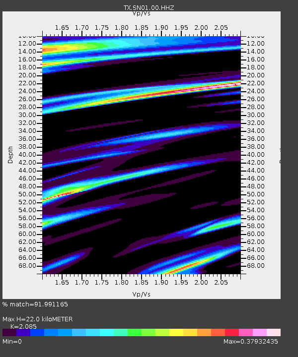
| Estimated Moho Depth: |
22.0 km |
| Estimated Crust Vp/Vs: |
2.09 |
| Assumed Crust Vp: |
6.426 km/s |
| Estimated Crust Vs: |
3.082 km/s |
| Estimated Crust Poisson's Ratio: |
0.35 |
|
| Radial Match: |
91.991165 % |
| Radial Bump: |
287 |
| Transverse Match: |
86.54007 % |
| Transverse Bump: |
400 |
| SOD ConfigId: |
2665671 |
| Insert Time: |
2018-05-18 22:38:29.694 +0000 |
| GWidth: |
2.5 |
| Max Bumps: |
400 |
| Tol: |
0.001 |
|
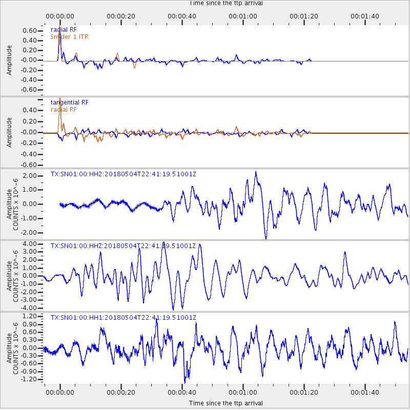
Signal To Noise
| Channel | StoN | STA | LTA |
| TX:SN01:00:HHZ:20180504T22:41:19.51001Z | 2.707464 | 4.980558E-7 | 1.8395659E-7 |
| TX:SN01:00:HH1:20180504T22:41:19.51001Z | 1.1143874 | 1.5693301E-7 | 1.4082447E-7 |
| TX:SN01:00:HH2:20180504T22:41:19.51001Z | 1.4259111 | 2.5544583E-7 | 1.791457E-7 |
| Arrivals |
| Ps | 3.9 SECOND |
| PpPs | 10 SECOND |
| PsPs/PpSs | 14 SECOND |


