You are here: Home > Network List > UW - Pacific Northwest Regional Seismic Network Stations List
> Station IRON Crane, OR, USA > Earthquake Result Viewer
IRON Crane, OR, USA - Earthquake Result Viewer
*The percent match for this event was below the threshold and hence no stack was calculated.
| Earthquake location: |
Near Coast Of Guatemala |
| Earthquake latitude/longitude: |
13.0/-90.2 |
| Earthquake time(UTC): |
2021/11/23 (327) 05:56:36 GMT |
| Earthquake Depth: |
49 km |
| Earthquake Magnitude: |
5.4 mww |
| Earthquake Catalog/Contributor: |
NEIC PDE/us |
|
| Network: |
UW Pacific Northwest Regional Seismic Network |
| Station: |
IRON Crane, OR, USA |
| Lat/Lon: |
43.36 N/118.47 W |
| Elevation: |
1226 m |
|
| Distance: |
38.8 deg |
| Az: |
326.589 deg |
| Baz: |
132.624 deg |
| Ray Param: |
$rayparam |
*The percent match for this event was below the threshold and hence was not used in the summary stack. |
|
| Radial Match: |
46.29652 % |
| Radial Bump: |
400 |
| Transverse Match: |
44.286495 % |
| Transverse Bump: |
400 |
| SOD ConfigId: |
26694651 |
| Insert Time: |
2021-12-07 06:12:38.292 +0000 |
| GWidth: |
2.5 |
| Max Bumps: |
400 |
| Tol: |
0.001 |
|
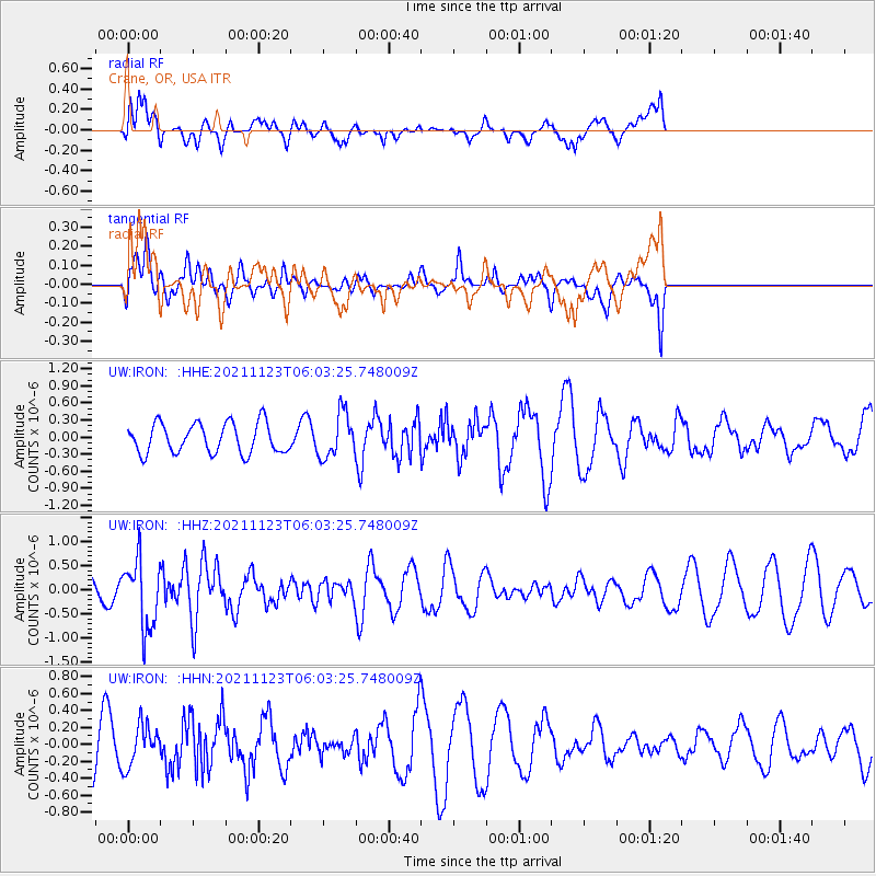
Signal To Noise
| Channel | StoN | STA | LTA |
| UW:IRON: :HHZ:20211123T06:03:25.748009Z | 3.3818824 | 6.9240275E-7 | 2.0473885E-7 |
| UW:IRON: :HHN:20211123T06:03:25.748009Z | 0.8346067 | 2.441823E-7 | 2.9257168E-7 |
| UW:IRON: :HHE:20211123T06:03:25.748009Z | 1.4714198 | 3.8521057E-7 | 2.6179515E-7 |
| Arrivals |
| Ps | |
| PpPs | |
| PsPs/PpSs | |


