You are here: Home > Network List > US - United States National Seismic Network Stations List
> Station AMTX Amarillo, Texas, USA > Earthquake Result Viewer
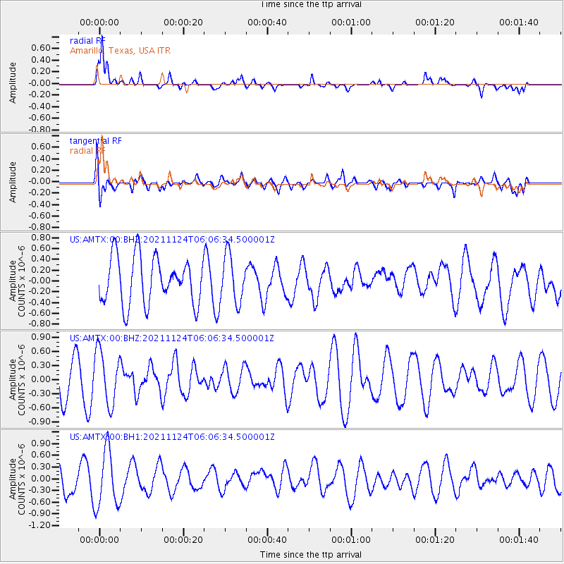
AMTX Amarillo, Texas, USA - Earthquake Result Viewer
*The percent match for this event was below the threshold and hence no stack was calculated.
| Earthquake location: |
Fiji Islands Region |
| Earthquake latitude/longitude: |
-16.9/175.2 |
| Earthquake time(UTC): |
2021/11/24 (328) 05:53:47 GMT |
| Earthquake Depth: |
10 km |
| Earthquake Magnitude: |
5.6 mww |
| Earthquake Catalog/Contributor: |
NEIC PDE/us |
|
| Network: |
US United States National Seismic Network |
| Station: |
AMTX Amarillo, Texas, USA |
| Lat/Lon: |
34.53 N/101.41 W |
| Elevation: |
1010 m |
|
| Distance: |
94.1 deg |
| Az: |
55.304 deg |
| Baz: |
252.4 deg |
| Ray Param: |
$rayparam |
*The percent match for this event was below the threshold and hence was not used in the summary stack. |
|
| Radial Match: |
78.226654 % |
| Radial Bump: |
400 |
| Transverse Match: |
53.410473 % |
| Transverse Bump: |
400 |
| SOD ConfigId: |
26694651 |
| Insert Time: |
2021-12-08 06:07:30.132 +0000 |
| GWidth: |
2.5 |
| Max Bumps: |
400 |
| Tol: |
0.001 |
|
Signal To Noise
| Channel | StoN | STA | LTA |
| US:AMTX:00:BHZ:20211124T06:06:34.500001Z | 1.5301964 | 5.7828566E-7 | 3.7791597E-7 |
| US:AMTX:00:BH1:20211124T06:06:34.500001Z | 2.1690788 | 7.3491066E-7 | 3.3881233E-7 |
| US:AMTX:00:BH2:20211124T06:06:34.500001Z | 0.992954 | 4.3736327E-7 | 4.4046678E-7 |
| Arrivals |
| Ps | |
| PpPs | |
| PsPs/PpSs | |


