You are here: Home > Network List > TX - Texas Seismological Network Stations List
> Station MNHN Monahans > Earthquake Result Viewer
MNHN Monahans - Earthquake Result Viewer
| Earthquake location: |
Hawaii |
| Earthquake latitude/longitude: |
19.4/-155.0 |
| Earthquake time(UTC): |
2018/05/04 (124) 22:32:55 GMT |
| Earthquake Depth: |
5.0 km |
| Earthquake Magnitude: |
5.8 Ml |
| Earthquake Catalog/Contributor: |
NEIC PDE/us |
|
| Network: |
TX Texas Seismological Network |
| Station: |
MNHN Monahans |
| Lat/Lon: |
31.34 N/102.76 W |
| Elevation: |
750 m |
|
| Distance: |
48.3 deg |
| Az: |
64.969 deg |
| Baz: |
268.702 deg |
| Ray Param: |
0.06944883 |
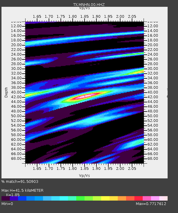
| Estimated Moho Depth: |
41.5 km |
| Estimated Crust Vp/Vs: |
1.85 |
| Assumed Crust Vp: |
6.121 km/s |
| Estimated Crust Vs: |
3.308 km/s |
| Estimated Crust Poisson's Ratio: |
0.29 |
|
| Radial Match: |
91.50903 % |
| Radial Bump: |
270 |
| Transverse Match: |
88.60765 % |
| Transverse Bump: |
368 |
| SOD ConfigId: |
2665671 |
| Insert Time: |
2018-05-18 22:38:48.136 +0000 |
| GWidth: |
2.5 |
| Max Bumps: |
400 |
| Tol: |
0.001 |
|

Signal To Noise
| Channel | StoN | STA | LTA |
| TX:MNHN:00:HHZ:20180504T22:41:07.075012Z | 3.8589127 | 4.903532E-7 | 1.2707031E-7 |
| TX:MNHN:00:HH1:20180504T22:41:07.075012Z | 4.280134 | 3.195048E-7 | 7.464831E-8 |
| TX:MNHN:00:HH2:20180504T22:41:07.075012Z | 1.1063583 | 1.0151956E-7 | 9.176011E-8 |
| Arrivals |
| Ps | 6.1 SECOND |
| PpPs | 18 SECOND |
| PsPs/PpSs | 24 SECOND |


