You are here: Home > Network List > AK - Alaska Regional Network Stations List
> Station E27K Coleen River, AK, USA > Earthquake Result Viewer
E27K Coleen River, AK, USA - Earthquake Result Viewer
| Earthquake location: |
Santa Cruz Islands |
| Earthquake latitude/longitude: |
-10.7/166.5 |
| Earthquake time(UTC): |
2021/11/25 (329) 12:04:10 GMT |
| Earthquake Depth: |
40 km |
| Earthquake Magnitude: |
6.0 mww |
| Earthquake Catalog/Contributor: |
NEIC PDE/us |
|
| Network: |
AK Alaska Regional Network |
| Station: |
E27K Coleen River, AK, USA |
| Lat/Lon: |
68.19 N/141.60 W |
| Elevation: |
654 m |
|
| Distance: |
86.9 deg |
| Az: |
17.136 deg |
| Baz: |
230.776 deg |
| Ray Param: |
0.04368425 |
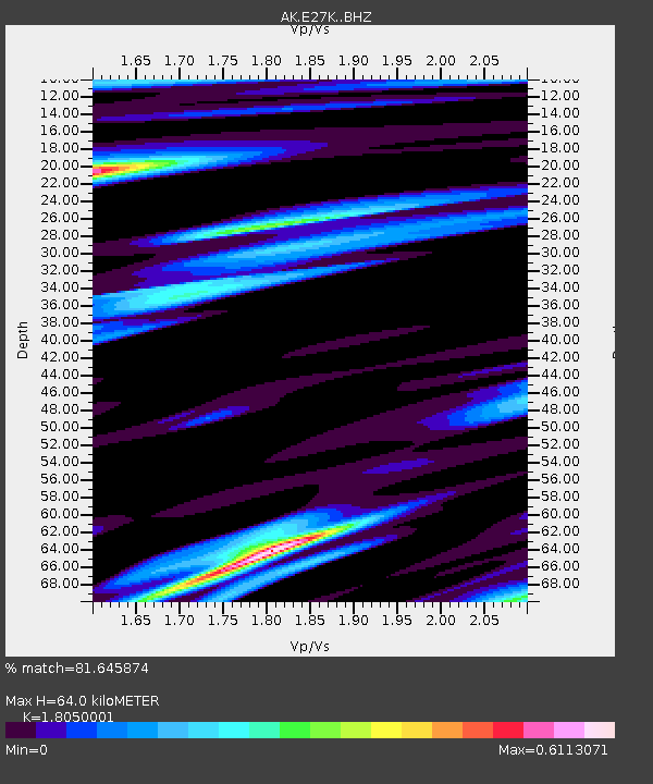
| Estimated Moho Depth: |
64.0 km |
| Estimated Crust Vp/Vs: |
1.81 |
| Assumed Crust Vp: |
6.522 km/s |
| Estimated Crust Vs: |
3.613 km/s |
| Estimated Crust Poisson's Ratio: |
0.28 |
|
| Radial Match: |
81.645874 % |
| Radial Bump: |
341 |
| Transverse Match: |
73.50227 % |
| Transverse Bump: |
330 |
| SOD ConfigId: |
26694651 |
| Insert Time: |
2021-12-09 12:06:07.676 +0000 |
| GWidth: |
2.5 |
| Max Bumps: |
400 |
| Tol: |
0.001 |
|

Signal To Noise
| Channel | StoN | STA | LTA |
| AK:E27K: :BHZ:20211125T12:16:19.300Z | 2.296997 | 8.5733944E-7 | 3.7324358E-7 |
| AK:E27K: :BHN:20211125T12:16:19.300Z | 0.9641808 | 3.7221105E-7 | 3.8603864E-7 |
| AK:E27K: :BHE:20211125T12:16:19.300Z | 1.3905541 | 2.9485892E-7 | 2.120442E-7 |
| Arrivals |
| Ps | 8.1 SECOND |
| PpPs | 27 SECOND |
| PsPs/PpSs | 35 SECOND |


