You are here: Home > Network List > AU - Australian Seismological Centre Stations List
> Station MUN Mundaring, Western Australia > Earthquake Result Viewer
MUN Mundaring, Western Australia - Earthquake Result Viewer
| Earthquake location: |
Santa Cruz Islands |
| Earthquake latitude/longitude: |
-10.7/166.5 |
| Earthquake time(UTC): |
2021/11/25 (329) 12:04:10 GMT |
| Earthquake Depth: |
40 km |
| Earthquake Magnitude: |
6.0 mww |
| Earthquake Catalog/Contributor: |
NEIC PDE/us |
|
| Network: |
AU Australian Seismological Centre |
| Station: |
MUN Mundaring, Western Australia |
| Lat/Lon: |
31.98 S/116.21 E |
| Elevation: |
253 m |
|
| Distance: |
50.8 deg |
| Az: |
237.445 deg |
| Baz: |
77.068 deg |
| Ray Param: |
0.067705974 |
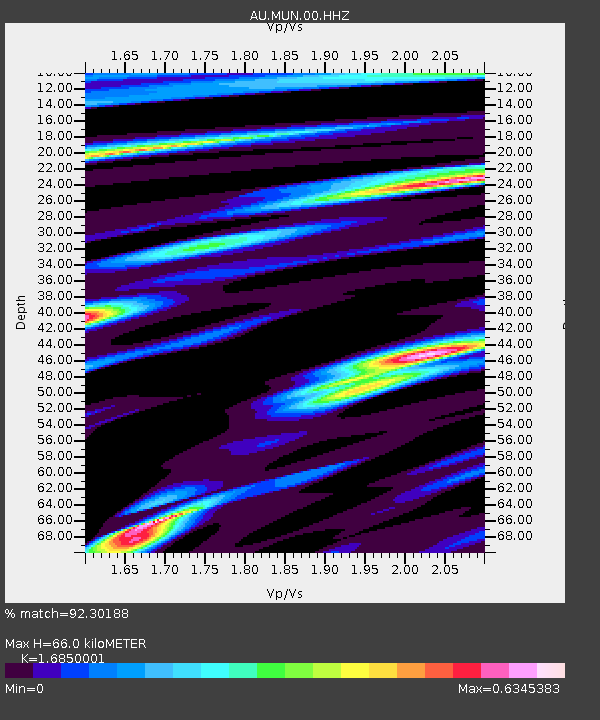
| Estimated Moho Depth: |
66.0 km |
| Estimated Crust Vp/Vs: |
1.69 |
| Assumed Crust Vp: |
6.419 km/s |
| Estimated Crust Vs: |
3.81 km/s |
| Estimated Crust Poisson's Ratio: |
0.23 |
|
| Radial Match: |
92.30188 % |
| Radial Bump: |
290 |
| Transverse Match: |
74.62786 % |
| Transverse Bump: |
361 |
| SOD ConfigId: |
26694651 |
| Insert Time: |
2021-12-09 12:09:00.867 +0000 |
| GWidth: |
2.5 |
| Max Bumps: |
400 |
| Tol: |
0.001 |
|

Signal To Noise
| Channel | StoN | STA | LTA |
| AU:MUN:00:HHZ:20211125T12:12:36.224988Z | 6.448965 | 1.1118065E-6 | 1.7240076E-7 |
| AU:MUN:00:HHN:20211125T12:12:36.224988Z | 2.2361417 | 2.9892885E-7 | 1.3368064E-7 |
| AU:MUN:00:HHE:20211125T12:12:36.224988Z | 3.914592 | 7.107491E-7 | 1.8156403E-7 |
| Arrivals |
| Ps | 7.5 SECOND |
| PpPs | 26 SECOND |
| PsPs/PpSs | 33 SECOND |


