You are here: Home > Network List > BK - Berkeley Digital Seismograph Network Stations List
> Station MCCM Marconi Conference Center, Marshall, CA, USA > Earthquake Result Viewer
MCCM Marconi Conference Center, Marshall, CA, USA - Earthquake Result Viewer
| Earthquake location: |
Santa Cruz Islands |
| Earthquake latitude/longitude: |
-10.7/166.5 |
| Earthquake time(UTC): |
2021/11/25 (329) 12:04:10 GMT |
| Earthquake Depth: |
40 km |
| Earthquake Magnitude: |
6.0 mww |
| Earthquake Catalog/Contributor: |
NEIC PDE/us |
|
| Network: |
BK Berkeley Digital Seismograph Network |
| Station: |
MCCM Marconi Conference Center, Marshall, CA, USA |
| Lat/Lon: |
38.14 N/122.88 W |
| Elevation: |
-7.7 m |
|
| Distance: |
81.8 deg |
| Az: |
48.727 deg |
| Baz: |
249.507 deg |
| Ray Param: |
0.047287717 |
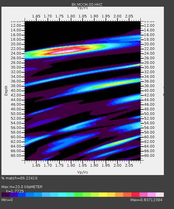
| Estimated Moho Depth: |
23.0 km |
| Estimated Crust Vp/Vs: |
1.77 |
| Assumed Crust Vp: |
6.472 km/s |
| Estimated Crust Vs: |
3.651 km/s |
| Estimated Crust Poisson's Ratio: |
0.27 |
|
| Radial Match: |
88.22418 % |
| Radial Bump: |
375 |
| Transverse Match: |
74.86697 % |
| Transverse Bump: |
400 |
| SOD ConfigId: |
26694651 |
| Insert Time: |
2021-12-09 12:11:38.923 +0000 |
| GWidth: |
2.5 |
| Max Bumps: |
400 |
| Tol: |
0.001 |
|

Signal To Noise
| Channel | StoN | STA | LTA |
| BK:MCCM:00:HHZ:20211125T12:15:53.628003Z | 1.9867828 | 7.082502E-7 | 3.5648094E-7 |
| BK:MCCM:00:HHN:20211125T12:15:53.628003Z | 1.2106261 | 4.986797E-7 | 4.1191885E-7 |
| BK:MCCM:00:HHE:20211125T12:15:53.628003Z | 1.4409422 | 5.9291506E-7 | 4.1147734E-7 |
| Arrivals |
| Ps | 2.8 SECOND |
| PpPs | 9.6 SECOND |
| PsPs/PpSs | 12 SECOND |


