You are here: Home > Network List > CC - Cascade Chain Volcano Monitoring Stations List
> Station BRSP Barrett Spur > Earthquake Result Viewer
BRSP Barrett Spur - Earthquake Result Viewer
| Earthquake location: |
Santa Cruz Islands |
| Earthquake latitude/longitude: |
-10.7/166.5 |
| Earthquake time(UTC): |
2021/11/25 (329) 12:04:10 GMT |
| Earthquake Depth: |
40 km |
| Earthquake Magnitude: |
6.0 mww |
| Earthquake Catalog/Contributor: |
NEIC PDE/us |
|
| Network: |
CC Cascade Chain Volcano Monitoring |
| Station: |
BRSP Barrett Spur |
| Lat/Lon: |
45.40 N/121.71 W |
| Elevation: |
2080 m |
|
| Distance: |
85.1 deg |
| Az: |
42.199 deg |
| Baz: |
249.542 deg |
| Ray Param: |
0.04491975 |
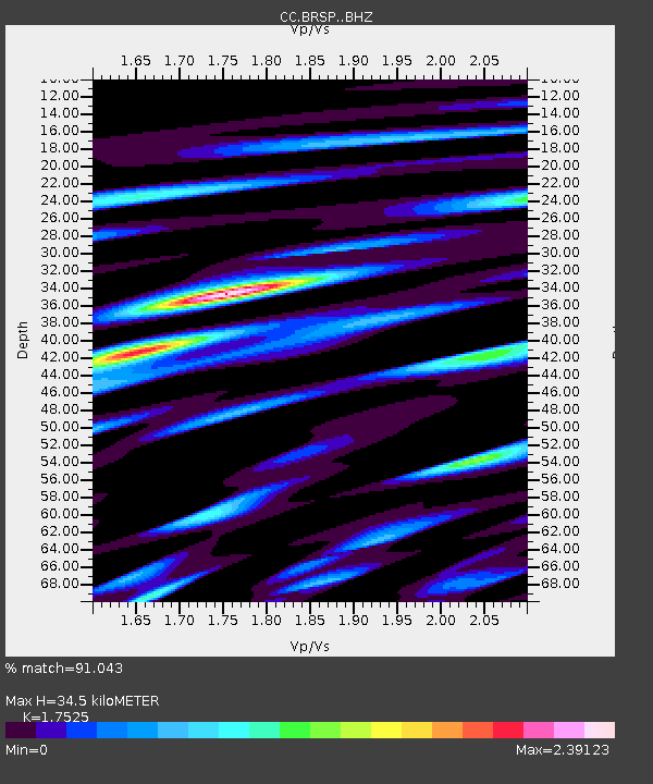
| Estimated Moho Depth: |
34.5 km |
| Estimated Crust Vp/Vs: |
1.75 |
| Assumed Crust Vp: |
6.597 km/s |
| Estimated Crust Vs: |
3.765 km/s |
| Estimated Crust Poisson's Ratio: |
0.26 |
|
| Radial Match: |
91.043 % |
| Radial Bump: |
290 |
| Transverse Match: |
80.004684 % |
| Transverse Bump: |
400 |
| SOD ConfigId: |
26694651 |
| Insert Time: |
2021-12-09 12:12:03.227 +0000 |
| GWidth: |
2.5 |
| Max Bumps: |
400 |
| Tol: |
0.001 |
|

Signal To Noise
| Channel | StoN | STA | LTA |
| CC:BRSP: :BHZ:20211125T12:16:10.82002Z | 3.130701 | 8.581057E-7 | 2.740938E-7 |
| CC:BRSP: :BHN:20211125T12:16:10.82002Z | 1.1713021 | 4.277992E-7 | 3.652339E-7 |
| CC:BRSP: :BHE:20211125T12:16:10.82002Z | 1.4986826 | 6.0764745E-7 | 4.0545441E-7 |
| Arrivals |
| Ps | 4.0 SECOND |
| PpPs | 14 SECOND |
| PsPs/PpSs | 18 SECOND |


