You are here: Home > Network List > CC - Cascade Chain Volcano Monitoring Stations List
> Station HOA Hoala > Earthquake Result Viewer
HOA Hoala - Earthquake Result Viewer
| Earthquake location: |
Santa Cruz Islands |
| Earthquake latitude/longitude: |
-10.7/166.5 |
| Earthquake time(UTC): |
2021/11/25 (329) 12:04:10 GMT |
| Earthquake Depth: |
40 km |
| Earthquake Magnitude: |
6.0 mww |
| Earthquake Catalog/Contributor: |
NEIC PDE/us |
|
| Network: |
CC Cascade Chain Volcano Monitoring |
| Station: |
HOA Hoala |
| Lat/Lon: |
46.24 N/122.19 W |
| Elevation: |
1151 m |
|
| Distance: |
85.1 deg |
| Az: |
41.291 deg |
| Baz: |
249.119 deg |
| Ray Param: |
0.04493411 |
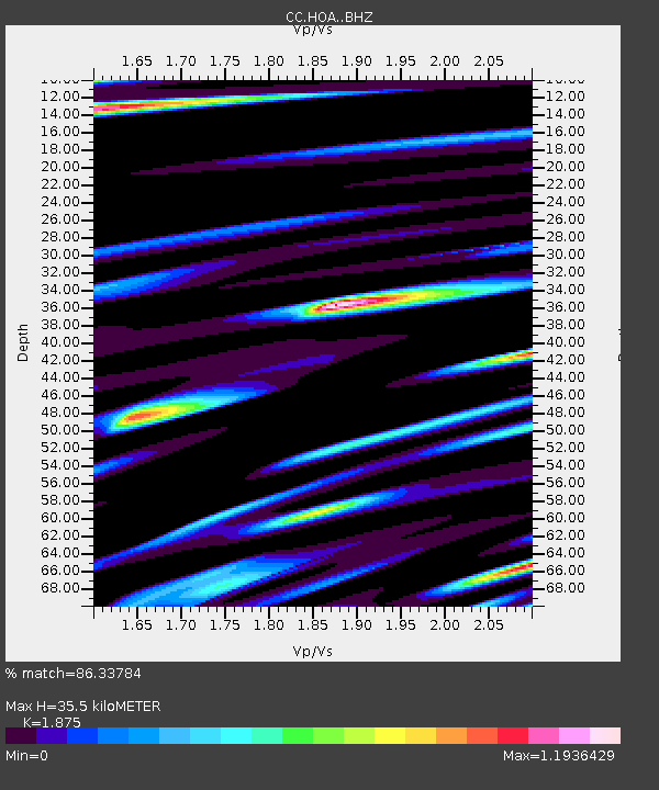
| Estimated Moho Depth: |
35.5 km |
| Estimated Crust Vp/Vs: |
1.88 |
| Assumed Crust Vp: |
6.566 km/s |
| Estimated Crust Vs: |
3.502 km/s |
| Estimated Crust Poisson's Ratio: |
0.30 |
|
| Radial Match: |
86.33784 % |
| Radial Bump: |
400 |
| Transverse Match: |
77.69916 % |
| Transverse Bump: |
400 |
| SOD ConfigId: |
26694651 |
| Insert Time: |
2021-12-09 12:12:53.048 +0000 |
| GWidth: |
2.5 |
| Max Bumps: |
400 |
| Tol: |
0.001 |
|

Signal To Noise
| Channel | StoN | STA | LTA |
| CC:HOA: :BHZ:20211125T12:16:10.740002Z | 4.6640215 | 8.702731E-7 | 1.8659286E-7 |
| CC:HOA: :BHN:20211125T12:16:10.740002Z | 0.747735 | 2.9759616E-7 | 3.979968E-7 |
| CC:HOA: :BHE:20211125T12:16:10.740002Z | 1.4220682 | 4.7530176E-7 | 3.342327E-7 |
| Arrivals |
| Ps | 4.8 SECOND |
| PpPs | 15 SECOND |
| PsPs/PpSs | 20 SECOND |


