You are here: Home > Network List > CI - Caltech Regional Seismic Network Stations List
> Station MPM Manuel Prospect Mine, California, USA > Earthquake Result Viewer
MPM Manuel Prospect Mine, California, USA - Earthquake Result Viewer
| Earthquake location: |
Santa Cruz Islands |
| Earthquake latitude/longitude: |
-10.7/166.5 |
| Earthquake time(UTC): |
2021/11/25 (329) 12:04:10 GMT |
| Earthquake Depth: |
40 km |
| Earthquake Magnitude: |
6.0 mww |
| Earthquake Catalog/Contributor: |
NEIC PDE/us |
|
| Network: |
CI Caltech Regional Seismic Network |
| Station: |
MPM Manuel Prospect Mine, California, USA |
| Lat/Lon: |
36.06 N/117.49 W |
| Elevation: |
185 m |
|
| Distance: |
85.2 deg |
| Az: |
52.1 deg |
| Baz: |
253.13 deg |
| Ray Param: |
0.04487907 |
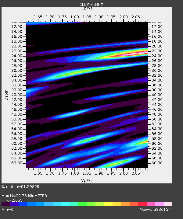
| Estimated Moho Depth: |
22.75 km |
| Estimated Crust Vp/Vs: |
2.06 |
| Assumed Crust Vp: |
6.279 km/s |
| Estimated Crust Vs: |
3.055 km/s |
| Estimated Crust Poisson's Ratio: |
0.34 |
|
| Radial Match: |
91.59829 % |
| Radial Bump: |
400 |
| Transverse Match: |
76.038124 % |
| Transverse Bump: |
400 |
| SOD ConfigId: |
26694651 |
| Insert Time: |
2021-12-09 12:13:48.294 +0000 |
| GWidth: |
2.5 |
| Max Bumps: |
400 |
| Tol: |
0.001 |
|
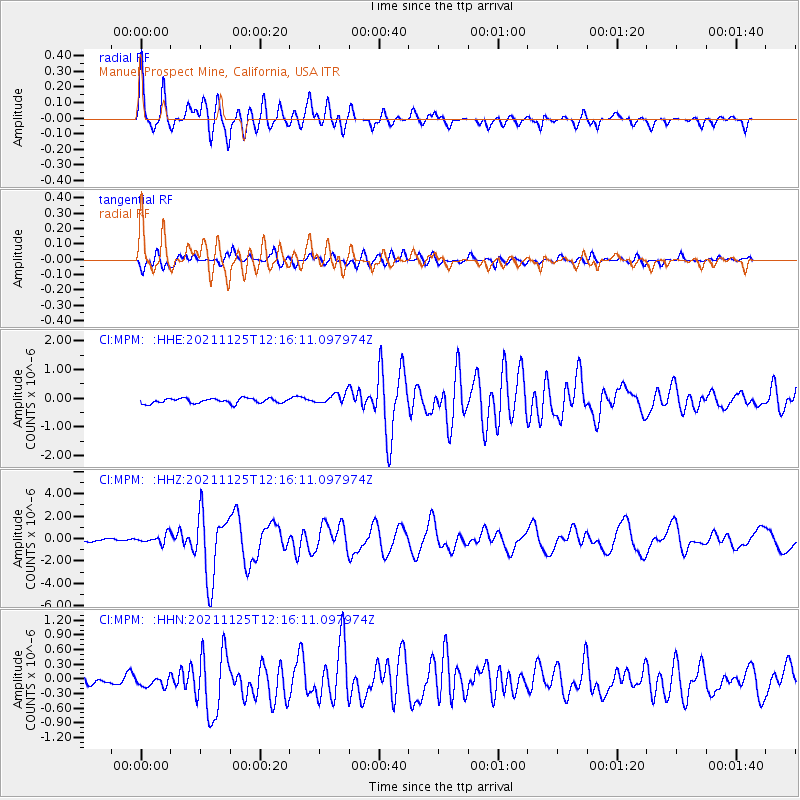
Signal To Noise
| Channel | StoN | STA | LTA |
| CI:MPM: :HHZ:20211125T12:16:11.097974Z | 3.2648432 | 4.0148325E-7 | 1.2297167E-7 |
| CI:MPM: :HHN:20211125T12:16:11.097974Z | 0.85690784 | 1.2110966E-7 | 1.4133337E-7 |
| CI:MPM: :HHE:20211125T12:16:11.097974Z | 2.2508175 | 1.9045427E-7 | 8.461559E-8 |
| Arrivals |
| Ps | 3.9 SECOND |
| PpPs | 11 SECOND |
| PsPs/PpSs | 15 SECOND |


